
| Previous Site | Next Site |
Earth Science Conservation Review
| Glenmornan River, Artigarvan | Tyrone |
| Site number: | 145 | ||
| ESCC: | EO | ||
| Locality Type: | Stream section | Status: | ESCR |
| Grid Reference: | C382008 | ||
| Google maps: | 54.85395,-7.40522 | ||
| County: | Tyrone | Council area: | Derry City & Strabane District Council |
| Period: | Precambrian | ||
| Stages: | Dalradian | ||
| Lithostrat: | Argyll Group, Dungiven Formation, Tayvallich Subgroup | ||
| Site Description | |
|---|---|
 | |
| Highlights: | |
The Glenmornan River at Artigarvan contains some of the earliest documented examples of pillow lavas in the Dalradian succession in Ireland. Characteristic pillow morphology can be seen at certain horizons within the predominantly green bed (amphibolite schist) rocks exposed in the bed of the river, south of Artigarvan. | |
| Introduction: | |
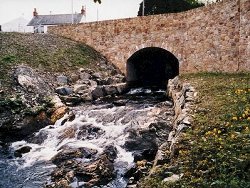
This site encompasses the bed and banks of the Glenmornan River and extends from a point about 250m upstream (south) of the bridge [H382 011] in the centre of Artigarvan on the B49 road from Plumbridge to Strabane, to a series of outcrops directly downstream of the bridge. The southern part of the site is most easily accessed from a field on the Moorlough Road beside the Strabane District Council Amenity Site [H382 008]. Access to the northern part is via the bridge in Artigarvan. On the first edition of the one inch to one mile geological map of the area (Sheet 17, Strabane (Geological Survey of Ireland, 1888, Kinahan et al., 1889), the metamorphic rocks in the area around Artigarvan were shown generally as "mica schists" no attempt being made to differentiate lithologies. The full significance of what Portlock (1843) described as the "greenstone slate" in the Strabane area, rocks which we now know extend as far north as Artigarvan, was first recognised by McCallien (1936), when, looking for a possible south-westerly continuation of the green beds of north-east Antrim, he described the Strabane Pillow Lavas including the locality at Artigarvan. Hartley (1938) and Arthurs (1976) suggested that the pillow lavas at Strabane and Artigarvan form part of the Dungiven Formation (Argyll Group, Tayvallich Subgroup), see table below, and could be correlated with pillow lavas at Craig [H523 981] on the opposite, inverted limb of the Sperrin Overfold. This correlation remains a reasonable working hypothesis although, the area between Craig and Strabane/Artigarvan, the axial region of the Sperrin Overfold, remains largely unsurveyed and confirmation of the lithostratigraphic status of the Artigarvan pillow lavas must await the outcome of more detailed mapping by the Geological Survey of Northern Ireland. TABLE TO BE ADDED Dalradian stratigraphy and ESCR sites in the northern Sperrin Mountains. | |
| Description: | |
The rocks exposed in the bed and banks of the Glenmornan River at Artigarvan form part of a mixed succession of strongly schistose and pale-grey and greenish grey platey schist and phyllite containing at least one prominent pillow lava unit (5-10m thick). At the top of the section, approximately 250m south of the bridge in Artigarvan the schist and phyllite have mixed composition and includes a distinctive quartz-chlorite schist which, at various horizons, is interbedded with thin (1-2cm) units of grey and dark blue crystalline limestone. The best exposures of pillow lavas occur in the river bed approximately 125m upstream of the bridge. Here, on smooth water worn surfaces, rock textures and morphological features are clearly visible. 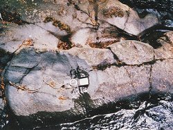 Directly downstream from the pillow lavas, outcrop quality deteriorates and much of the bedrock is concealed by dumping and the foundations of outbuildings at the animal feed mill on the west bank. The outcrop that is visible consists primarily of amphibolite schists rich in actinolite and plagioclase feldspar. North of the bridge in Artigarvan, outcrops of pillow lavas described by McCallien (1936) appear to have been covered up by recent bridge strengthening work. The remaining outcrop is dominated by siliciclastic metasediments, mainly thinly bedded, platey quartzite interbedded with phyllite. The strata here are cut by a major, 2m wide quartz vein complex trending 100°45°S. All but the most massive lithologies at Artigarvan have a well developed, close-spaced penetrative cleavage which dips consistently towards the north-west. This is a persistent (S2) fabric which characterises the rocks throughout the region. | |
| Importance: | |
This site is important because it contains some of the earliest recorded occurrences of Dalradian pillow lavas in Ireland. Occurrences such as these are relatively rare in Ireland. As part of the Dungiven Formation, these lavas constitute one of the most important stratigraphic marker horizons in the Dalradian succession. It is anticipated that this locality will play an important role in a forthcoming research project investigating geochemical characteristics of Dalradian magmatism. The Artigarvan site is also likely to play an important role in extending stratigraphic correlations throughout the south Londonderry and north-west Tyrone areas when, during the next five years, the Geological Survey of Northern Ireland's mapping programme extends to this area. | |
| Interpretation: | |
The close association of lithologies such as limestone, quartzite, amphibolitic schists, and basaltic pillow lavas at the Artigarvan site is strong evidence to support the inclusion of these strata within the Dungiven Formation (Argyll Group) (Hartley, 1938, Arthurs, 1976). Lithologies such as limestone, quartzite and quartz phyllite indicate that comparatively stable shallow water marine shelf depositional environments prevailed at this time. The presence of pillow lavas and amphibolite schists on the other hand indicates that volcanic activity took place contemporaneously contributing lavas and probably tuffaceous sediment to the basin. Throughout the Dalradian in the north of Ireland and Scotland, similar associations of igneous and sedimentary rocks of equivalent age represent an important stratigraphic marker horizon. These rocks are manifestations of important tectonic changes which took place towards the end of the Middle Dalradian. At this time a tensional tectonic regime was established along the continental margin of Laurentia, as a large ocean opened to the south-east. The continental crust along this margin became dilated and thinned, a process which was accompanied by the onset of a major episode of basaltic magmatism. The rocks of the Dungiven Formation therefore represent an important transition within the Dalradian stratigraphy. Before the Dungiven Formation was deposited, in Lower and Middle Dalradian times, with a few exceptions, stable shallow water shelf environments prevailed. Following the deposition of the Dungiven Formation, sedimentation during Upper Dalradian times was dominantly in unstable, rapidly subsiding, marginal marine basins which were infilled rapidly by siliciclastic turbidite facies sediments. During the late-Caledonian Orogeny, these rocks were deformed, folded and subjected to regional metamorphism. Metamorphic mineral assemblages typically include chlorite, biotite, muscovite and albite-oligoclase +/- tourmaline, and are consistent with Greenschist Facies conditions within the Barrovian Facies Series (Arthurs, 1976). Structurally, these rocks now lie on the northern, upwards facing limb of the Sperrin Overfold (F2) and have a well developed, penetrative, axial planar fabric (S2). | |
| Conclusions: | |
This is an important geological site containing one of the first recorded occurrences of pillow lavas in the Dalradian in Ireland. The site is likely to continue to play an important national role in ongoing research into the stratigraphy and structure of the Dalradian in Northern Ireland and an international role in extending Dalradian correlations between Ireland and Scotland. | |
| Notes: | |
For site specific information and references on other Dalradian sites in the Sperrin Mountains, Londonderry and Tyrone see the following sites: For Central and Southern Sperrin Mountains: Key Site 130 - Butterlope Glen Key Site 131 - Craig Key Site 132 - Mullaghcarbatagh Key Site 133 - Henry's Bridge, Glensass Burn Key Site 134 - Oughtboy Burn Key Site 135 - Garvagh Burn Key Site 136 - Barnes Gap Key Site 137 - Barnes Burn Key Site 138 - Golan Burn Key Site 139 - Glendarragh Burn, Glenlark Key Site 140 - Mountfield Old Quarry Key Site 141 - McNally's Burn, Broughderg For North Sperrin Mountains and Londonderry: Key Site 142 - Letterbrat Quarry Key Site 143 - Banagher Glen Quarry Key Site 144 - Strabane Quarry Key Site 146 - Balix Hill Key Site 147 - Drain Quarry Key Site 148 - Kildoag Quarry Key Site 149 - Loughermore Mountain Key Site 150 - Burntollet and Tamnymore Wood Key Site 151 - Dog Leap, Limavady Key Site 152 - Kittybane Quarry Key Site 153 - Prehen Quarry Key Site 154 - Creevagh Hill Old Quarry For site specific information and references on other Dalradian sites in North-east Antrim see the following sites: Key Site 155 - Benvan Key Site 156 - Escort Port Key Site 157 - Torr Head Key Site 158 - Altmore Burn Key Site 159 - Leckpatrick Point Key Site 160 - Carnaneigh Key Site 161 - Loughan Bay Key Site 162 - Loughareema Channel Key Site 163 - Knocknacarry Bridge Key Site 164 - Cushendun Bay and Rock Port For general information on the Dalradian rocks of Northern Ireland see the following site: Key Site 124 - The Dalradian Rocks of Northern Ireland For general and site specific information on the Pre-Dalradian rocks of Northern Ireland see the following site: Key Site 123 - The Pre-Dalradian Rocks of Northern Ireland For general information and an extensive reference list on the Precambrian of Northern Ireland see the following site: Key Site 122 - An Introduction to the Precambrian of Northern Ireland | |
| Keywords | |
|---|---|
| Rocks: | Lava, Phyllite, Pillow lava, Schist |
| Access | |
|---|---|
| Management: | |
This site occurs entirely within the confines of the bed and banks of the Glenmornan River. At the time of reporting, the principle threat to the integrity of the site appeared to come from fly-tipping and dumping from the Moorlough Road which runs close and parallel to the right hand bank of the river. Also, on the left bank of the river, directly south of the bridge, the concrete foundations of outhouses at the animal feed mill have encroached on and covered parts of the outcrop in the river. There has also been some dumping of metal and building waste in the river at this point. Since this is a river site, steps should be taken to ensure that water quality is maintained and that any discharges directly upstream of the site are strictly controlled. | |
| Threats: | Fly-tipping and dumping. |
| References (5) | |||
|---|---|---|---|
| Arthurs, J.W., 1976a. The geology and metalliferous mineral potential of the Sperrin Mountains area Geological Survey of Northern Ireland Special Report. | |||
| Hartley, J.J., 1938. The Dalradian rocks of the Sperrin Mountains and adjacent areas in Northern Ireland Proceedings of the Royal Irish Academy, vol. 44 pt. B. | |||
| Kinahan, G.H., Wilkinson, S.B., Nolan, J. & Eagan, B.A., 1889. Explanatory Memoir to accompany Sheet 17 of the maps of the Geological Survey of Ireland Memoirs of the Geological Survey of Ireland. | |||
| McCallien, W.J., 1936. A note on Dalradian Pillow lavas Proceedings of the Royal Irish Academy, vol. 43, pp.13-22. | |||
| Portlock, J.E., 1843. Report on the Geology of the County of Londonderry and of parts of Tyrone and Fermanagh. HMSO, Dublin. | |||
| Map(s): | GSI (1888). 1:63,360 Geological Sheet 17 (Strabane), Dublin, OS for GSI | ||
| Record type: | ESCR report | ||
| Entered by: | E M Porter | ||
| Last updated: | 6 Jun 2005 | ||
| Enlander, I., Dempster, M. & Doughty, P., 2026. Glenmornan River, Artigarvan, County Tyrone, site details. [In] Earth Science Conservation Review. https://www.habitas.org.uk/escr/site.php?item=145. Accessed on 2026-11-06. |
| Previous Site | Next Site |