
| Previous Site | Next Site |
Earth Science Conservation Review
| Kildoag Quarry | Londonderry |
| Site number: | 148 | ||
| ESCC: | EA | ||
| Locality Type: | Quarry (working) | Status: | ESCR |
| Grid Reference: | C498085 Centroid | ||
| Google maps: | 54.92209,-7.2233 | ||
| County: | Londonderry | Council area: | Derry City & Strabane District Council |
| Period: | Precambrian | ||
| Stages: | Dalradian | ||
| Lithostrat: | Claudy Formation, Southern Highlands Group | ||
| Site Description | |
|---|---|
 | |
| Highlights: | |
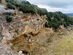
The quarry at Kildoag contains high quality outcrops of quartz psammite, quartz-mica schist and thin pelite units which form part of the Claudy Formation. These rocks clearly display beddingcleavage relationships and sedimentary structures. This is one of only a few remaining sites producing "Claudy Stone", the distinctive platy, brown-weathering, rock previously used widely as a building stone. | |
| Introduction: | |
Kildoag Quarry is located in Kildoag Townland, about 5km west-northwest of Claudy and 7km SSE of Drumahoe. Access is from Kildoag Road which runs along the eastern flank of Slievekirk, high on the western side of the valley of the River Faughan. On the first edition of the one inch to one mile geological map of the area (Dungiven, Sheet 18) (Geological Survey of Ireland, 1884) strata in the vicinity of this site were included within the general category "mica schists" of the "Altered Lr Silurian". Pitcher & Berger (1972) included the rocks of this part of Co. Londonderry within the "Lough Foyle Succession", a broad group encompassing all of the Upper Dalradian strata in the Northern Sperrins and Lough Foyle Basin. Arthurs (1976) proposed a more detailed stratigraphy for the area based largely on earlier work by Hartley (1938). Despite some recent controversy concerning the age and structure of the rocks in Sperrins (Alsop et al.,1993, Arthurs et al.,1994), Arthurs's revised stratigraphy forms the working stratigraphic framework for further mapping in the area (Geological Survey of Northern Ireland, 1997). The strata at Kildoag form part of the Claudy Formation, the lowermost formation in the Southern Highland Group in the north Sperrin Mountains. The Claudy Formation is a thick succession of quartz-rich psammites with subordinate pelite estimated at between 2000m and 4000m thick (Arthurs, 1976), see table below. TABLE TO BE ADDED Dalradian stratigraphy and ESCR sites in the northern Sperrin Mountains. | |
| Description: | |
The Kildoag site is a partly derelict quarry with the main face about10m high and a bench cut at 5m towards the south-western end. Throughout the quarry, the predominant lithology is orange- brown weathering quartz-rich psammite in the form of well-bedded units up to 1m thick separated by thin partings of silvery grey, micaceous and chloritic phyllite and by occasionally thicker units of grey to black phyllite and pelite. There appears to be some cyclicity in the succession with sedimentary "packages" comprising several psammite beds with only thin pelite partings, separated from one another by thicker units of pelite and semi-pelitic lithologies. Bedding (S0) is conspicuous throughout the quarry and strata dip consistently towards the north and north-west (075°10°-35°N). The psammite units have a coarse, sometimes gritty, granular texture, and contain blue and grey detrital quartz together with pink and white detrital feldspars. Clasts up to 2mm diameter are not uncommon. Despite these variations in grain-size, no unambiguous graded bedding was observed. However, the geometry of the bedforms of some of the psammite units strongly suggests that the succession is right way up, that is, younging towards the north. All rocks at this site are cut by a close-spaced, penetrative cleavage (80°40°N) which everywhere appears to be subparallel to, but more steeply inclined than, bedding. This cleavage is the regionally dominant fabric (S2) which is related to the major (F2) folding in the Sperrin Mountains. Towards the base of the quarry, a thick silvery grey phyllite and pelite unit appears to underlie the quarry floor. Minor folding of one of these beds results in a small-scale, south-easterly verging F2 fold pair with horizontal axes and well developed axial planar cleavage. The cleavage and bedding geometry at this site, combined with some tentative way-up evidence and minor fold vergence all points to these strata being located the northern, upwards facing limb of the Sperrin Overfold. | |
| Importance: | |
In an otherwise poorly exposed area, Kildoag Quarry contains some of the best and most accessible exposures of the typical coarse-grained arenaceous rocks which constitute the bulk of the Claudy Formation. Sedimentary and structural features are well displayed in good 3-dimensional outcrop. | |
| Interpretation: | |
The sediments which form the rocks at this site and in the rest of the Claudy Formation were originally deposited in a comparatively near shore open-marine environment. During late-Caledonian times, Dalradian rocks throughout the British Isles, underwent major regional deformation accompanied by metamorphism. As a result of folding and south-easterly directed translation, the strata of the Claudy Formation now lie on the northern, upwards-facing limb of the Sperrin Overfold. This structure has long been interpreted as the south-western continuation of the Tay Nappe in Scotland (Pitcher et al., 1972). The metamorphism that accompanied deformation was comparatively low grade. Mineral assemblages recorded elsewhere in the Claudy Formation (chlorite + epidote +/- actinolite +/- quartz) indicate metamorphism within the Greenschist Facies of the high-pressure Barrovian Facies Series. Arthurs (1976) correlated the Claudy Formation with the Dart Formation on the opposite, inverted limb of the Sperrin Overfold. The Claudy Formation consists of lithologies including limestone, quartzite, quartz feldspar psammite which for the most part indicate shallow water near-shore environments whereas the Dart Formation is a typically coarse-grained turbidite sequence derived from a continental source with sporadic but widespread input of mafic volcanic debris (Harris et al., 1994). It is possible that the Claudy Formation represents a more proximal shelf facies which changed laterally southwards into the basinal open marine turbidite facies of the Dart Formation. There is also the possibility that the entire sequence has been foreshortened as a result of south-east and east-south-easterly directed folding and thrusting during the D2 and D3 deformational events. | |
| Conclusions: | |
A strong case can be made for conserving the Kildoag Quarry as a site of national importance. It provides a good stratigraphical and structural reference section in the otherwise poorly exposed Claudy Formation. The site is also one of few remaining quarries producing "Claudy Stone" which formerly was a widely used local building stone. | |
| Notes: | |
For site specific information and references on other Dalradian sites in the Sperrin Mountains, Londonderry and Tyrone see the following sites: For Central and Southern Sperrin Mountains: Key Site 130 - Butterlope Glen Key Site 131 - Craig Key Site 132 - Mullaghcarbatagh Key Site 133 - Henry's Bridge, Glensass Burn Key Site 134 - Oughtboy Burn Key Site 135 - Garvagh Burn Key Site 136 - Barnes Gap Key Site 137 - Barnes Burn Key Site 138 - Golan Burn Key Site 139 - Glendarragh Burn, Glenlark Key Site 140 - Mountfield Old Quarry Key Site 141 - McNally's Burn, Broughderg For North Sperrin Mountains and Londonderry: Key Site 142 - Letterbrat Quarry Key Site 143 - Banagher Glen Quarry Key Site 144 - Strabane Quarry Key Site 145 - Glenmornan River, Artigarvan Key Site 146 - Balix Hill Key Site 147 - Drain Quarry Key Site 149 - Loughermore Mountain Key Site 150 - Burntollet and Tamnymore Wood Key Site 151 - Dog Leap, Limavady Key Site 152 - Kittybane Quarry Key Site 153 - Prehen Quarry Key Site 154 - Creevagh Hill Old Quarry For site specific information and references on other Dalradian sites in North-east Antrim see the following sites: Key Site 155 - Benvan Key Site 156 - Escort Port Key Site 157 - Torr Head Key Site 158 - Altmore Burn Key Site 159 - Leckpatrick Point Key Site 160 - Carnaneigh Key Site 161 - Loughan Bay Key Site 162 - Loughareema Channel Key Site 163 - Knocknacarry Bridge Key Site 164 - Cushendun Bay and Rock Port For general information on the Dalradian rocks of Northern Ireland see the following site: Key Site 124 - The Dalradian Rocks of Northern Ireland For general and site specific information on the Pre-Dalradian rocks of Northern Ireland see the following site: Key Site 123 - The Pre-Dalradian Rocks of Northern Ireland For general information and an extensive reference list on the Precambrian of Northern Ireland see the following site: Key Site 122 - An Introduction to the Precambrian of Northern Ireland | |
| Keywords | |
|---|---|
| Rocks: | Psammite, Quartz psammite |
| Access | |
|---|---|
| Management: | |
Kildoag Quarry still operates periodically, producing rough 'Claudy Stone' which is used locally for architectural detailing and landscape gardening. The main points of geological interest can be demonstrated at a number of separate locations distributed throughout the quarry and there is sufficient outcrop to facilitate continued rock extraction and conservation at this site. There is no requirement to designate particular parts of the quarry for special protection or to impose sampling or access restrictions, beyond any which may in future be agreed with the quarry owners. None of the quarry faces exceeds 10m height and at present all appear to be reasonably stable. However, as with all quarries, care must be taken when examining the quarry faces. All such areas are potentially unstable and rockfalls can be precipitated by hammering or moving across unstable boulder screes. |
| References (6) | |||
|---|---|---|---|
| Alsop, G.I. & Hutton, D.H.W., 1993. Major southeast-directed Caledonian thrusting and folding in the Dalradian rocks of mid-Ulster: implications for Caledonian tectonics and mid-crustal shear zones Geological Magazine, vol. 130 pt. 2, pp.233-244. | |||
| Arthurs, J.W., 1976a. The geology and metalliferous mineral potential of the Sperrin Mountains area Geological Survey of Northern Ireland Special Report. | |||
| Arthurs, J.W., Smith, R.A. & Johnston, T.P., 1994. Discussion on major southeast-directed Caledonian thrusting and folding in the Dalradian on mid-Ulster: implications for Caledonian tectonics and mid-crustal shear zones Geological Magazine, vol. 131 pt. 3, pp.417-421. | |||
| Harris, A.L., Haselock, P.J., Kennedy, M.J. & Mendum, J.R., 1994. The Dalradian Supergroup in Scotland, Shetland and Ireland Geological Society of London Special Report, In A revised correlation of Precambrian rocks in the British Isles. | |||
| Hartley, J.J., 1938. The Dalradian rocks of the Sperrin Mountains and adjacent areas in Northern Ireland Proceedings of the Royal Irish Academy, vol. 44 pt. B. | |||
| Pitcher, W.S. & Berger, A.R., 1972. The Geology of Donegal: A study of granite emplacement and unroofing Wiley - Interscience, New York & London. | |||
| Map(s): | GSI (1884). 1:63,360 Geological Sheet 18 (Dungiven), Dublin, OS for GSI GSNI (1997). 1:250,000 Northern Ireland, Solid Geology (2nd edition), BGS, Keyworth, Nottingham | ||
| Record type: | ESCR report | ||
| Entered by: | E M Porter | ||
| Enlander, I., Dempster, M. & Doughty, P., 2026. Kildoag Quarry, County Londonderry, site details. [In] Earth Science Conservation Review. https://www.habitas.org.uk/escr/site.php?item=148. Accessed on 2026-11-06. |
| Previous Site | Next Site |