
| Previous Site | Next Site |
Earth Science Conservation Review
| Waterloo - Penarth and Jurassic | Antrim |
| Site number: | 16 | File Number: | D40 |
| ESCC: | EF | ||
| Locality Type: | Coastal section | Status: | ASSI |
| Grid Reference: | D410034,D409038 End(s) of linear site, Not Entered | ||
| Google maps: | 54.85891,-5.80424 | ||
| County: | Antrim | Council area: | Mid & East Antrim Borough Council |
| Period: | Cretaceous, Jurassic, Triassic | ||
| Stages: | Jurassic Undifferentiated, Norian, Rhaetian, Santonian | ||
| Lithostrat: | Collin Glen Formation, Mercia Mudstone Group, Penarth Group, Port More Formation, Ulster White Limestone Formation, Waterloo Mudstone Formation, Westbury Formation | ||
| Site Description | |
|---|---|
 | |
| Highlights: | |
The low cliffs and foreshore near Waterloo Cottages, Larne, Co. Antrim (D409037) offer some of the best exposures in Ireland of Rhaetic and Lower Lias strata, particularly the former, and provide excellent opportunities for fossil collection. | |
| Introduction: | |
For about 700m, from a point SE of Chaine Park (D410034) to the shore east of Pebble Lodge, the foreshore offers good but often discontinuous exposures of beds, mainly mudrocks, dipping NW at about 25 deg. The lowest beds seen are red marls of the Port More Formation overlain by green-grey marls of the Collin Glen Formation. Above these are the grey shales and mudstones of the Rhaetian Penarth Group, which marks the incursion of the sea over the dry continental plains of the lower part of the Trias and has a marine bivalve fauna. The Rhaetic passes up into, though the actual contact is obscured and may be a fault, the grey marine mudstones and thin limestones of the Lias Waterloo Mudstone Formation, the only Jurassic rocks preserved in Ulster, which occur under the Cretaceous Ulster White Limestone Formation about the flanks of the Antrim Plateau. The rocks of this section, termed here the Waterloo Mudstone Formation after Waterloo Cottage which lies near the centre, were first described by Tate (1864, 1867) and by Hull (1876). The most recent account is by Ivimey-Cook (1975) and the area has recently been resurveyed and a new map published (GSNI, 1994). | |
| Description: | |
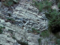
The lowest beds seen are poorly-exposed red Mercia Mudstones of the Port More Formation, present in the grassed slopes and on the foreshore below Bank Head (D410034). A short distance north greenish grey mudstones of the Collin Glen Formation are exposed in the cliffs and on the foreshore. These mudstones are about 12m thick with numerous pseudo-pisoliths and pseudo-oolites, probable signs of low-grade metasomatism connected to the proximity of the Larne Lough Fault, here not far offshore. The uppermost beds of the Collin Glen Formation and most of the Westbury Formation are exposed in the bank west of the promenade 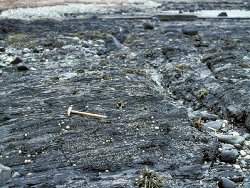 In the Larne No. 1 borehole, about 2km to the SW of Waterloo, the Rhaetian strata are a minimun of 35.49m thick, but the succession seen here totals only ~24.01m. Two small faults seen on the fore- shore may, however, have cut out some of the mudstone succession. The Rhaetian succession recorded on the foreshore (Ivimey-Cook, 1975) is: WATERLOO MUDSTONE FORMATION (part) Mudstone, grey, micaceous, silty, rather sheared; Protocardia philippiana, Pteromya cf. wilkesleyensis, 1.52m Mudstone, grey, hard, micaceous, rather silty, 1.17m Shale, dark grey, blocky, 1.14m Shale, hard, calcareous, 0.08m Shale, grey, fissile, 0.28m Limestone, grey, hard, 0.08m Shale, grey, hardened; top 0.30m with numerous silty laminae, Protocardia cf. rhaetica, Pteromya tatei, 1.65m Shale, grey, hardened, silty and calcareous layers, 1.93m Mudstone, silty, with sandy lenticles, 1.57m Not seen, 0.30m PENARTH GROUP Shales, calcareous, with thin limestone ribs, 3.40m Mudstones and shales, cross-bedded, pseudo-ooliths at top, 4.90m Grey calcareous mudstone, 2.00m Fault Calcareous mudstone, 0.43m Sandstone, buff, with shale laminae, 0.50m Shale with thin sandstone bands, 1.20m Fault Buff sandstone and grey shales, 1.15m Grey shale, 0.61m Grey sandy shale; lenticles of buff sandstone; Eotrapezium?, Rhaetavicula contorta, 0.90m Non-sequence to Collin Glen Formation At the top of the Penarth Group is an apparently conformable passage to the lowest beds of the Jurassic Waterloo Mudstone Formation. The lowest beds are shales and a thin limestone with a few fossils (Protocardia cf. rhaetica, Pteromya tatei), but after about 9.72m the lithology changes to massive grey mudstones with abundant fossils, including the Zone fossil Psiloceras planorbis, abundant in the beds which cross the landward end of the sewage outfall. The planorbis Zone beds of the Waterloo Mudstone Formation, totalling ~16.13m, can be followed as a series of small reefs up to the line of a Palaeogene dolerite dyke which crosses the foreshore following the strike of the Lias beds: WATERLOO MUDSTONE FORMATION (part) Mudstone, grey, massive. Basal 0.9 m contain crinoid columnals, Cardina hennocquii, Modiolus laevis, Plagiostoma gigantea, Pseudolimea sp., Psiloceras belcheri, 3.00m Mudstone, grey, occasional very thin siltstone bands, Cardinia hennocquii, Psiloceras sp., 0.30m Siltstone, calcareous, 0.01m Mudstone, grey more fissile, with occasional nodular calcareous siltstones, Cardinia hennocquii, Pteromya tatei, Psiloceras sp., 1.70m Mudstone, grey, rich in Cardinia sp., 0.10m Mudstone, grey, massive, 8.00m Mudstone, grey, with Modiolus laevis, Psiloceras planorbis, 0.05m Mudstone, grey, massive, with Psiloceras planorbis, 1.20m Mudstone, grey, massive, Psiloceras planorbis in base also echinoid spines, Lucina cf. limbata, Modiolus laevis, Ryderia cf. graphica, ostrocods, 1.32m NW of the dyke a poorly exposed sequence of mudstones, rotten basalt and sheared strata suggests another fault zone trending NE-SW. Beyond this the foreshore is heavily littered with loose boulders and only small scattered exposures can be seen. These show that the strike swings to nearly N-S while the dip remains about 25 deg. to the west. West of the small low-water embayment the lithology changes from the grey mudstones of the planorbis Zone through an unproved thickness of mudstones of the liasicus Zone to the alternating grey mudstones and thin grey limestones of the angulata Zone. The foreshore is much obscured by boulders but some 27.5m east of Waterloo Cottage a section shows ~6.7m of beds belonging to this zone (Ivimey-Cook, 1975): WATERLOO MUDSTONE FORMATION Limestone, 0.08m Obscured, 0.30m Limestone, grey, nodular, 0.08m Shale, dark grey, calcareous with Schlotheimia sp., 0.99m Limestone, grey, nodular, 0.05m Shale, dark grey, 0.05m Limestone, 0.10m Shale, calcareous, locally becoming a lenticular limestone, 0.38m Alternations of thin limestone and calcareous shales, limestones are pale grey and lenticular, Schlotheimia sp., 2.84m Limestone, hard, 0.25m Shale, grey, silty, 0.13m Limestone, grey, much iron staining, 0.30m Obscured, 0.45m Shale, dark grey, silty, poorly bedded, coprolites, 0.62m Higher beds of more massive mudstones are seen in a small cliff immediately south of the Waterloo Cottage. About 150m north of these exposures a small outcrop of about 0.9m of shelly crinoidal limestone and grey mudstones was seen among the boulders just east of Pebble Lodge, apparently separated by a fault from an exposure of grey shale and limestone with a northerly dip, about 20m north. No diagnostic fossils were found in either outcrop, but specimens in the Queen's University collection, apparently from these exposures include Coroniceras (Metaphioceras) sp. and Arnioceras cf bodleyi, indicating the bucklandi and possibly semicostatum Zones. | |
| Importance: | |
Though Lias and Rhaetian beds underlie most of the Cretaceous Ulster White Limestone Formation of NE Ireland, good exposures are rare because of the extensive landslips and mudslides which rim the basalts of the Antrim Plateau. The Waterloo exposure, though largely masked by beach boulders, is therefore of considerable importance in the context of Irish geological studies and, as a western-most exposure in Europe, in the studies of continental palaeogeography. | |
| Interpretation: | |
The section from the top of the Rhaetian to Pebble Lodge, about 100m in thickness, is the stratotype for the Waterloo Mudstone Formation. Above the basal 9.72m which is Triassic in age, the next 16.13m belongs to the planorbis Zone. The poor exposure does not allow any clear estimates of the angulata and bucklandi Zones, but species diagnostic of these have been recorded from the section. | |
| Conclusions: | |
The foreshore, with a sea wall and promenade behind it, is in no immediate danger unless subject to exceptional marine erosion. Normal erosion will expose fresh fossils and allow continued collection by student parties without problem. | |
| Notes: | |
For information on other Jurassic sites see Key Site 1205 - Portrush - Jurassic and Key Site 1206 - Tircreven Burn. For general information on the Jurassic System in N. Ireland see Key Site 1193 - The Jurassic System in N. Ireland - Introduction. | |
| Keywords | |
|---|---|
| Rocks: | Basalt, Crinoidal limestone, Dolerite, Limestone, Marl, Mudstone, Shale |
| Fossil Groups: | Ammonite, Bivalve, Coral, Crinoid, Goniatite |
| Fossil List: | Arctica islandica , Arnsbergites facatus, Nuclana pernula , Psiloceras planorbis (J. de C. Sowerby), Siphonophyllia benburbensis |
| Structures: | fault |
| Relations: | Marine sediments |
| Measurements | |||||
|---|---|---|---|---|---|
| Length: | ~700 m | Width: | Height: | ||
| Depth: | Area: | ||||
| Access | |
|---|---|
| Approach: | From A2 N of Larne. The site can be reached through Chaine Park or from the carpark in front of the Leisure Centre. |
| Restrictions: | Tidal |
| Management: | |
The foreshore, with a sea wall and promenade behind it, is in no immediate danger unless subject to exceptional marine erosion. Normal erosion will expose fresh fossils and allow continued collection by student parties without problem. | |
| Threats: | Erosion |
| References (4) | |||
|---|---|---|---|
| Hull, E., 1876. The country around Antrim, Larne and Carrickfergus. Memoirs of the Geological Survey of Ireland. | |||
| Ivimey-Cook, H.C., 1975. The stratigraphy of the Rhaetic and Lower Jurassic in East Antrim. Bulletins of the Geological Survey of Great Britain, numb. 50, pp.51-70. | |||
| Tate, R., 1864. On the Liassic strata of the neighbourhood of Belfast. Quarterly Journal of the Geological Society of London, vol. 20, pp.103-114. | |||
| Tate, R., 1867. On the Lower Lias of the north-east of Ireland. Quarterly Journal of the Geological Society of London, vol. 23, pp.291-305. | |||
| Map(s): | GSNI 1:50,000 Larne | ||
| Map No: | Sheet 21 | ||
| Record type: | Environment Serv. GIS, ESCR report | Recorded by: | Wilson, H.E. |
| Entered by: | Crowther, P.R. | ||
| Enlander, I., Dempster, M. & Doughty, P., 2026. Waterloo - Penarth and Jurassic, County Antrim, site details. [In] Earth Science Conservation Review. https://www.habitas.org.uk/escr/site.php?item=16. Accessed on 2026-11-08. |
| Previous Site | Next Site |