
| Previous Site | Next Site |
Earth Science Conservation Review
| Carnaneigh - Dalradian | Antrim |
| Site number: | 160 | ||
| ESCC: | EO | ||
| Locality Type: | Crag, Crags | Status: | ESCR |
| Grid Reference: | D256365 Centroid | ||
| Google maps: | 55.16015,-6.02937 | ||
| County: | Antrim | Council area: | Causeway Coast & Glens Borough Council |
| Period: | Precambrian | ||
| Stages: | Dalradian | ||
| Lithostrat: | Carnaneigh Green Beds, Runabay Head Formation, Southern Highlands Group | ||
| Site Description | |
|---|---|
 | |
| Highlights: | |
Carnaneigh contains the stratotype (type area) for the Carnaneigh Green Bed Member, the highest stratigraphic subdivision of the Runabay Head Formation. These strata constitute an important marker horizon within the Southern Highland Group (Upper Dalradian) in north-east Antrim. This site facilitates the study of lithological variation within the green beds and also contains good examples of folds and other deformation structures. | |
| Introduction: | |
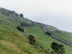
This site is located on the south-eastern slopes of Carnaneigh, a rocky knoll in Aughnasillagh Townland about 4km N of Cushendun. Access to the site is via Torr Road which runs north from Cushendun. On the first edition of the one inch to one mile geological map of the area (Ballycastle, Sheet 8 (Geological Survey of Ireland, 1887), the rocks at Carnaneigh were simply classified as "crystalline schists" and were not distinguished from the surrounding lithologies. McCallien (1931) commented on the similarities between rocks at Carnaneigh and green beds within the Dalradian succession in SW Scotland. Bailey & McCallien (1934) produced a detailed lithostratigraphic map of north-east Antrim showing the extent of the green beds at Carnaneigh and were the first geologists to discuss the wider significance of green beds within the Dalradian. The second edition of the Ballycastle Sheet, (Geological Survey of Northern Ireland, 1963) and the accompanying Memoir (Wilson et al., 1966) contained a revised lithostratigraphy based on detailed mapping. The predominantly chloritic green beds at Carnaneigh were distinguished from hornblendic and biotitic type green beds at Leckpatrick and as a result, a revised interpretation of the regional structure was proposed (Wilson et al., 1966). A more formal approach to lithostratigraphic terminology for the north-east Antrim Dalradian was introduced on the first edition of the Solid Geology Map of Northern Ireland (Geological Survey of Northern Ireland, 1977) and the chloritic green beds in the vicinity of Carnaneigh were named the Carnaneigh Green Beds. Arthurs (1976) was responsible for a major revision of the Dalradian geology of north-east Antrim in the course of which he defined a new lithostratigraphic framework using local formation names, see table below. Although it was based on a reconnaissance mapping programme and further detailed work is required in this area, Arthurs' linework and lithostratigraphy was incorporated in the second edition of the Solid Geology Map of Northern Ireland (Geological Survey of Northern Ireland, 1997). The current status of the Carnaneigh Green Bed Member, is as the uppermost defined stratigraphic division within the Runabay Head Formation. TABLE TO BE ADDED Dalradian stratigraphy and ESCR sites in North-east Co. Antrim. | |
| Description: | |
At Carnaneigh Hill and across an extensive area to the south-east, on either side of the coast road, there are extensive outcrops of pale grey and green quartz-chlorite-biotite schists (green beds) interbedded with albite-biotite schists and gritty quartz-biotite psammitic schists. These form part of a major green bed horizon (Carnaneigh Green Bed Member), which marks the stratigraphic base of the of the Runabay Head Formation (is equivalent to the Ben Ledi Grit?, Beinn Bheula Schist?). The green beds directly north of Lignadaughtan and south-east of Carnaneigh summit on the landward side of the coast road, dip east-south-east at about 25°. In places these rocks have been intensely deformed and tightly folded developing small scale interfolial and disharmonic structures. Some larger (metre-scale), flat-lying open folds structures have a well-developed spaced, axial-planar cleavage (S2?). 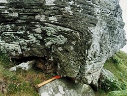 | |
| Importance: | |
This site is of national and arguably international stratigraphic importance and although not yet formally designated, could be considered as a possible stratotype (type section) for the Carnaneigh Green Bed Member. The Carnaneigh Green Bed Member is an important and distinctive marker horizon within the otherwise monotonous Southern Highland Group succession in north-east Antrim. This site offers excellent exposures and is a particularly useful reference point for geologists mapping the stratigraphy and structure of the area. The significance of these green beds was also recognised by McCallien (1931) who proposed the earliest systematic correlation between the Dalradian rocks of Scotland and Ireland. | |
| Interpretation: | |
During Upper Dalradian times a series of ensialic marine basins developed along the unstable margin of the Laurentian continent. These basins were infilled by turbidite facies sediments derived from erosion of the nearby continental landmass. Although these sediments were predominantly siliciclastic, sedimentation patterns did change periodically and from time to time, basic volcaniclastic sediments dominated. These variations resulted either from a change in the source area for the sediment or perhaps more plausibly from the effects of contemporaneous volcanic activity on the nearby continental margins. Green beds are a common feature of the Upper Dalradian stratigraphy throughout Northern Britain. The tectonic extension and break-up of the continental margin of Laurentia resulted in crustal thinning and a major upsurge of volcanic activity. This activity persisted well into Upper Dalradian times and is represented in the stratigraphic record in places by basaltic lavas but more commonly by green beds. Green beds in the Dalradian of Ireland and Scotland are now routinely interpreted as being turbiditic sediments which are admixtures of siliciclastic and basic volcaniclastic sediment (Gunn, 1897; Pickett 1998). During the Caledonian Orogeny, the Dalradian rocks underwent intense deformation and regional metamorphism. As in Scotland and the Sperrin Mountains deformation was polyphase and resulted in folding and formation of up to four cleavages (Arthurs, 1976; Goldring, 1961). Structurally, the rocks of the Carnaneigh Green Bed Member now lie on the inverted limb of the Altmore Anticline which is regarded as the south-westwards continuation into Ireland of the Cowal Anticline in SW Scotland (Gunn et al., 1892; Arthurs, 1976). Deformation was accompanied by relatively low-grade regional metamorphism. The strata at Carnaneigh contain mineral assemblages which indicate that metamorphism took place within the quartz-albite-muscovite-chlorite sub-facies of the Greenschist Facies. | |
| Conclusions: | |
Carnaneigh is a site of established national importance and potentially international significance. It provides good reference sections and a potential stratotype for the Carnaneigh Green Bed Member of the Runabay Head Formation. | |
| Notes: | |
For site specific information and references on other Dalradian sites in North-east Antrim see the following sites: Key Site 155 - Benvan Key Site 156 - Escort Port Key Site 157 - Torr Head Key Site 158 - Altmore Burn Key Site 159 - Leckpatrick Point Key Site 161 - Loughan Bay Key Site 162 - Loughareema Channel Key Site 163 - Knocknacarry Bridge Key Site 164 - Cushendun Bay and Rock Port For site specific information and references on other Dalradian sites in the Sperrin Mountains, Londonderry and Tyrone see the following sites: For Central and Southern Sperrin Mountains: Key Site 130 - Butterlope Glen Key Site 131 - Craig Key Site 132 - Mullaghcarbatagh Key Site 133 - Henry's Bridge, Glensass Burn Key Site 134 - Oughtboy Burn Key Site 135 - Garvagh Burn Key Site 136 - Barnes Gap Key Site 137 - Barnes Burn Key Site 138 - Golan Burn Key Site 139 - Glendarragh Burn, Glenlark Key Site 140 - Mountfield Old Quarry Key Site 141 - McNally's Burn, Broughderg For North Sperrin Mountains and Londonderry: Key Site 142 - Letterbrat Quarry Key Site 143 - Banagher Glen Quarry Key Site 144 - Strabane Quarry Key Site 145 - Glenmornan River, Artigarvan Key Site 146 - Balix Hill Key Site 147 - Drain Quarry Key Site 148 - Kildoag Quarry Key Site 149 - Loughermore Mountain Key Site 150 - Burntollet and Tamnymore Wood Key Site 151 - Dog Leap, Limavady Key Site 152 - Kittybane Quarry Key Site 153 - Prehen Quarry Key Site 154 - Creevagh Hill Old Quarry For general information on the Dalradian rocks of Northern Ireland see the following site: Key Site 124 - The Dalradian Rocks of Northern Ireland For general and site specific information on the Pre-Dalradian rocks of Northern Ireland see the following site: Key Site 123 - The Pre-Dalradian Rocks of Northern Ireland For general information and an extensive reference list on the Precambrian of Northern Ireland see the following site: Key Site 122 - An Introduction to the Precambrian of Northern Ireland This site is also important for Structural Geology. See Key Site 650 - Carnaneigh. | |
| Keywords | |
|---|---|
| Minerals: | Chlorite, Epidote |
| Rocks: | Schist |
| Access | |
|---|---|
| Approach: | Access to the site is from the Torr Road which is narrow and has limited scope for parking cars. |
| Management: | |
This site lies entirely within fenced pastureland and consists of a series of natural outcrops together with massive fallen and slumped blocks. Many of these blocks contain features of general structural and lithological interest and should be considered as an integral part of the site. Exposure is abundant and there is no reason to impose sampling or hammering bans. | |
| References (7) | |||
|---|---|---|---|
| Arthurs, J.W., 1976a. The geology and metalliferous mineral potential of the Sperrin Mountains area Geological Survey of Northern Ireland Special Report. | |||
| Bailey, E.B. & McCallien, W.J., 1934. The metamorphic rocks of North-east Antrim Transactions of the Royal Society of Edinburgh: Earth Sciences, vol. 58, pp.163-177. | |||
| Golding, D.C., 1961. The relationship of the micro-fabric to the small-scale structures of the Dalradian of north-eastern Antrim Proceedings of the Royal Irish Academy, vol. 61 pt. B, pp.345-367. | |||
| Gunn, W., Clough, C.T. & Hill, J.B., 1897. The Geology of Cowal Memoir of the Geological Survey of Scotland. | |||
| McCallien, W.J., 1931. A contribution to the correlation of the Dalradian rocks of Scotland Geological Magazine, vol. 68, pp.153-175. | |||
| Pickett, E., 1998. An introduction to the Green Beds of the Southern Highland Group of the Scottish Dalradian: previous research and an account of preliminary work carried out in 1997. British Geological Survey Technical Report, numb. WA/97/92. | |||
| Wilson, H.E. & Robbie, J.A., 1966. Geology of the country around Ballycastle. Memoirs of the Geological Survey Northern Ireland. | |||
| Map(s): | GSI (1887). 1:63,360 Geological Sheet 8 (Ballycastle), Dublin, OS for GSI GSNI (1963). 1:63,360 Ballycastle, Northern Ireland Sheet 8, Drift, Southampton, OS for GSNI GSNI (1977). 1:250,000 Northern Ireland, Solid Geology (1st edition), Southampton, OS for IGS GSNI (1997). 1:250,000 Northern Ireland, Solid Geology (2nd edition), BGS, Keyworth, Nottingham | ||
| Record type: | ESCR report | ||
| Entered by: | E M Porter | ||
| Last updated: | 8 Jan 2005 | ||
| Enlander, I., Dempster, M. & Doughty, P., 2026. Carnaneigh - Dalradian, County Antrim, site details. [In] Earth Science Conservation Review. https://www.habitas.org.uk/escr/site.php?item=160. Accessed on 2026-11-06. |
| Previous Site | Next Site |