
| Previous Site | Next Site |
Earth Science Conservation Review
| Carrickmacsparrow Townland | Fermanagh |
| Site number: | 192 | File Number: | H13 |
| ESCC: | EO | ||
| Locality Type: | Inland exposure | Status: | ASSI |
| Grid Reference: | H137409 Centroid | ||
| Google maps: | 54.31713,-7.78946 | ||
| County: | Fermanagh | Council area: | Fermanagh & Omagh District Council |
| Period: | Carboniferous | ||
| Stages: | Asbian, Visean | ||
| Lithostrat: | Carrickmacsparrow Limestone Member, Dartry Limestone Formation | ||
| Site Description | |
|---|---|
 | |
| Highlights: | |
This lithostratigraphical unit only occurs in Subarea-1 in Co. Fermanagh and was first recognised at its stratotype section in the eponymous townland. It occurs near the top of the Dartry Formation and differs from enclosing lithologies in lacking chert and consisting of pale coloured grainstones. | |
| Description: | |
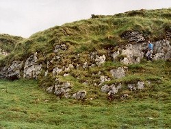
The Carrickmacsparrow Member was identified as a new lithostratigraphical unit by the GSNI (1991) during the remapping of the Derrygonnelly - Marble Arch area of Co. Fermanagh. It occurs some 30m below the top of the Dartry Limestone Formation and is present both on the south side of Belmore Mountain and on Cuilcagh Mountain. The type locality occurs near the north end of Carrickmacsparrow Townland (H137 409) in a west-facing low cliff (Photograph 14) about 1km southwest of Lough Nagor and 5.75km east-northeast of Belcoo. The member consists of 4m of fawn to medium grey, unbedded fine-grained microsparite and coarsely crinoidal biopelsparite which have sharp upper and lower contacts with the dark grey bedded cherty limestones typical of the Dartry Formation. Numerous stylolites are present and grain size gradually decreases upwards through the member. The lower part of the member comprises fawn-grey crinoidal biosparites in which all bioclasts are micritised and are usually less than 1mm although some brachiopod and bryozoan fragments may exceed 2mm. Crinoid ossicles are replaced by coarse calcite spar. Towards the top of the member there are dark grey biopelsparites in which bioclasts, consisting mainly of scattered crinoid ossicles and brachiopod fragments, are scattered in a matrix of micritised pellets and a calcite spar cement. Silicification is confined to partial replacement of isolated ossicles. On the north and east flanks of Cuilcagh Mountain is a grainstone some 11-15m thick, that occurs 45m below the top of the formation and which may be equivalent to the Carrickmacsparrow Member. | |
| Interpretation: | |
The Carrickmacsparrow Limestone Member was identified during remapping of the area south of Belmore Mountain and is a distinctive horizon located just below the top of the Dartry Formation, and above the Knockmore Limestone Member. Grainstones are characteristically mud-free and individual particles form an interlocking self-supporting framework. The absence of lime-mud is usually taken to indicate deposition in active, turbulent water with strong winnowing currents and water depths therefore tend to be shallow, at or just above wave base. The occurrence of grading and of erosional channels and cross-laminations indicates a probable origin as current-swept carbonate sand bars or shoals and is evidence of, at least periodic, shallow water conditions in the top part of the Dartry Limestone across the whole basin, irrespective of a former position either on the subsiding part or the virtually static fulcral zone of the carbonate ramp. | |
| Conclusions: | |
This member is an important aid in producing accurate geological maps of various parts of Subarea-1, on the south side of Belmore Mountain and around Cuilcagh Mountain. The stratotype section occurs on Belmore Mountain. | |
| Notes: | |
For information on other sites in Subarea-1 see; Key Site 1174 - Subarea-1; Derrygonnelly-Marble Arch-Cuilcagh. | |
| Keywords | |
|---|---|
| Rocks: | Limestone |
| Fossil Groups: | Brachiopod, Crinoid |
| Relations: | Marine sediments |
| Access | |
|---|---|
| Approach: | 1km SW of Lough Nagor and 5.75km ENE of Belcoo. |
| Map(s): | See 1:50,000 O.S. Sheet 17 (Lower Lough Erne); GSNI (1991) 1:50,000 Sheet 44, 56 and 43 (Derrygonnelly & Marble Arch). | ||
| Record type: | ESCR report | ||
| Entered by: | Doughty, P.J. | ||
| Last updated: | 8 Jan 2005 | ||
| Enlander, I., Dempster, M. & Doughty, P., 2026. Carrickmacsparrow Townland, County Fermanagh, site details. [In] Earth Science Conservation Review. https://www.habitas.org.uk/escr/site.php?item=192. Accessed on 2026-11-06. |
| Previous Site | Next Site |