
| Previous Site | Next Site |
Earth Science Conservation Review
| Lisnaskea road cutting | Fermanagh |
| Site number: | 206 | File Number: | H33 |
| ESCC: | ED | ||
| Locality Type: | Roadside section | Status: | ESCR |
| Grid Reference: | H36213375 Centroid | ||
| Google maps: | 54.25136,-7.44461 | ||
| County: | Fermanagh | Council area: | Fermanagh & Omagh District Council |
| Period: | Carboniferous | ||
| Stages: | Visean | ||
| Lithostrat: | Benbulben Shale Formation, Dartry Limestone Formation | ||
| Site Description | |
|---|---|
 | |
| Highlights: | |
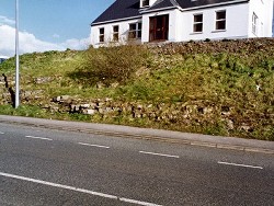
As far as is known this road section is the only locality in Subarea-2 that exposes the contact between the Benbulben Shale Formation and the succeeding Dartry Limestone Formation. | |
| Description: | |
The road cutting is located on the southeast side of the Derrylin Road, 60m north of Balfour Castle on the west side of Lisnaskea and measures about 30m long. Some 7m of strata, dipping east at between 6-8 deg., are exposed of which the top 4.6m are the basal beds of the Dartry Limestone Formation and the remaining 2-3m represent the top beds of the Benbulben Shale Formation. The Glencar Limestone Formation is not represented in this section or in this part of south Co. Fermanagh. I - BENBULBEN SHALE FORMATION Between 2 and 3m of dark grey-brown calcareous mudstones and thin limestones occur at the SW end of the cutting and represent the Benbulben Shale. 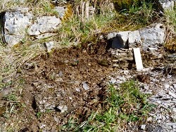 Earlandia sp. lituotubellid indet. Mediocris sp. Paraarchaediscus sp. Priscella sp. Pseudoammodiscus sp. Septabrunsiina sp. Viseidiscus sp. and a single bilaminar fragment of the alga Koninckopora. II - DARTRY LIMESTONE FORMATION The 4.6m of strata forming the top part of the sequence in this road cutting are assigned to the Dartry Limestone Formation. They consist of interbedded thin to thick limestones and thin splintery calcareous mudstones. Bedding in the limestones is conspicuously undulose but this appears to be a compaction feature unrelated, in contrast to many other levels in this formation, to the growth of large nodules of black secondary chert. Chert, where present, takes the form of small, scattered nodules and a 0.02m bed, about 0.4m above the formation base. Lithologically the limestones are very fine-grained spicular, bioturbated packstones and lime mudstones with fish and conodont debris. The microbiota is both stunted and impoverished and, in the lowest bed of the formation, includes the following foraminifera and algae; Archaediscus sp? Earlandia sp. Endothyra sp. Paraarchaediscus sp. Priscella sp. Pseudoammodiscus sp. Tetrataxis sp. Viseidiscus sp. Calcisphaeres Koninckopora inflata No macrofauna was recovered from these strata. | |
| Interpretation: | |
The transitional strata between the Benbulben Shale Formation and the Dartry Limestone Formation indicate a rapid decline in the amount of mud and silt detritus reaching the basin. The virtual absence of macrofauna is a good indication of an unfavourable environment and this impression is reinforced by the stunted nature of the foraminifera and virtual absence of algae. The latter fact, coupled with the occurrence of Viseidiscus in post- Arundian sediments, is taken to indicate deposition in a relatively deep water carbonate facies with a transported microfauna and flora. | |
| Conclusions: | |
In Subarea-2 the road cutting at Lisnaskea is a unique section exposing strata covering the boundary between the Benbulben Shale and Dartry Limestone formations. | |
| Notes: | |
For information on other sites in Subarea-2 see; Key Site 1175 - Subarea-2; Lisnaskea-Fivemiletown. | |
| Keywords | |
|---|---|
| Rocks: | Limestone, Mudstone |
| Fossil Groups: | Foraminifera |
| Fossil List: | Viseidiscus sp. |
| Relations: | Marine sediments |
| Measurements | |||||
|---|---|---|---|---|---|
| Length: | ~30 m | Width: | Height: | 7 m | |
| Depth: | Area: | ||||
| Access | |
|---|---|
| Approach: | The road cutting is located on the SE side of the Derrylin Road, 60m north of Balfour Castle on the west side of Lisnaskea. |
| Record type: | ESCR report | ||
| Entered by: | Doughty, P.J. | ||
| Enlander, I., Dempster, M. & Doughty, P., 2026. Lisnaskea road cutting, County Fermanagh, site details. [In] Earth Science Conservation Review. https://www.habitas.org.uk/escr/site.php?item=206. Accessed on 2026-11-06. |
| Previous Site | Next Site |