
| Previous Site | Next Site |
Earth Science Conservation Review
| Moffatt's Quarry, Drumquin | Tyrone |
| Site number: | 228 | File Number: | H37 |
| ESCC: | EA | ||
| Locality Type: | Quarry (working) | Status: | local interest |
| Grid Reference: | H3171 1 km square | ||
| Google maps: | 54.58677,-7.52049 | ||
| County: | Tyrone | Council area: | Fermanagh & Omagh District Council |
| Period: | Carboniferous | ||
| Stages: | Visean | ||
| Lithostrat: | Ballyshannon Limestone Formation, Bundoran Shale Formation, Ederny Limestone Member, Tyrone Group | ||
| Site Description | |
|---|---|
 | |
| Highlights: | |
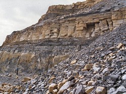
This is by far the most complete and thickest section through any part of the Bundoran Shale Formation that is known to occur in the Kesh-Omagh area. In addition the formation base and its contact with the underlying Ederny Limestone Member of the Ballyshannon Formation is also exposed. The Skea Sandstone Member was not deposited in this area. | |
| Description: | |
Moffatt's Quarry is located in the northeastern part of the Carboniferous outcrop in the Kesh-Omagh area. It is the largest and deepest quarry in the area and occurs at the southern end of a linear development that extends for almost 2km to the NW to Collow Townland (H307 731), although all other quarries are now closed. The exposure in these quarries, of the Ballyshannon Limestone and Bundoran Shale, is quite exceptional and allows the measurement of some 90m of strata straddling the formation boundary. The top of the Ballyshannon Limestone is marked by the Ederny Limestone Member which is 3.7m thick. In all the quarries the western rim of the main face is equivalent to the upper surface of the Ederny Member. In the central quarries (H31 72) in Dunnaree Townland this surface is exposed over a strike length of 700m and there is no evidence of attenuation, erosion or cut-out of this single bed of limestone, beneath the base of the succeeding Bundoran Shale. The stratigraphical sequence in Moffatt's Quarry is split into two parts by a W-E orientated normal fault, downthrowing to the north, that occurs almost in the middle of the quarry. On the south side of the fault the entire face of the quarry, with the exception of the very highest few metres of strata, consists of bedded limestones of the Ballyshannon Limestone. On the north side of the fault only one-half of the strata exposed by quarrying operations, in the lower (eastern) face, belong to the Ballyshannon Limestone, the upper half forming the lower part of the Bundoran Shale. About 40m of strata in the lower part of the Bundoran Shale are measurable in this quarry. Near the base the most distinctive horizon consists of 1.3m of black mudstones and siltstones. These are underlain by the basal beds of the Bundoran Shale consisting of 1.4m of unfossiliferous grey siltstones and shaley mudstones with thin and thick beds of peritidal fenestrate micrites with rhizoliths (rootlet cavities). The top micrite in this section is 0.35m thick and is visible, in contrast with the overlying black shales, as a prominent pale-coloured bed near the base of the section. These beds rest on the flat to very greatly undulose top surface of the Ederny Member and the Skea Sandstone Member is not developed here. Fresh exposures of the Bundoran Shale, such as in Moffatt's Quarry, demonstrate the importance, and variability, of the carbonate content of these rocks. Hard, thick beds of calcareous siltstone, weathering with a distinctive yellow patina, are interbedded with dark grey, poorly calcareous shales and blocky mudstones. Limestones are restricted to thin, usually less than 0.05m thick, lenticular beds but are very fossiliferous, in particular crinoid debris and huge numbers of chonetid brachiopods. The formation becomes increasingly fossiliferous in higher strata with the appearance of large brachiopods such as Delepinea carinata and D.destinezi and a coral fauna, that is very common and diagnostic of a mid-Arundian age and includes the following species. Colonial corals: Siphonodendron martini S. sociale Solitary corals: Amplexus coralloides Caninia cf. cornucopiae Cravenia cf. lamellata C. rhytoides C. cf. tela Koninckophyllum carlyanense K. fragile Michelinia megastoma M. cf. tenuisepta Palaeosmuilia murchisoni Siphonophyllia caninoides S. garwoodi Spirophyllum praecursor | |
| Interpretation: | |
Peritidal facies sediments representing the basal beds of the Bundoran Shale are exposed in Moffatt's Quarry and at a few other places in the linear network of quarries developed on the east face of Dunnaree Hill, Drumquin. These were deposited in a marginal marine environment where water depths fluctuated and permitted the temporary colonisation of the exposed sea bed by plants, which left the trace of rootlet horizons. The bed of black mudstones and siltstones, 1.3m thick just above the base, contains a few fossils dominated by ostracods and bivalves. These conditions were still clearly unsuitable for a truly marine benthos but the succeeding strata all contain crinoid debris and a good marine fauna of brachiopods, bryozoa and corals. | |
| Conclusions: | |
The exposures of the Ballyshannon Limestone and, more unusually, of the Bundoran Shale in Moffatt's Quarry at Drumquin are quite exceptional and, in the case of the latter formation cannot be replicated anywhere else in N. Ireland. | |
| Notes: | |
For information on other sites in Subarea-3 see; Key Site 1176 - Subarea-3; Kesh-Omagh. | |
| Keywords | |
|---|---|
| Rocks: | Limestone, Shale |
| Fossil Groups: | Arthropod, Bivalve, Brachiopod, Coral, Crinoid, Plant, Polyzoan |
| Fossil List: | Siphonodendron martini |
| Access | |
|---|---|
| Approach: | SE side of Dunnaree Hill, 3km SW of Drumquin. |
| Record type: | ESCR report | ||
| Entered by: | Doughty, P.J. | ||
| Enlander, I., Dempster, M. & Doughty, P., 2026. Moffatt's Quarry, Drumquin, County Tyrone, site details. [In] Earth Science Conservation Review. https://www.habitas.org.uk/escr/site.php?item=228. Accessed on 2026-11-06. |
| Previous Site | Next Site |