
| Previous Site | Next Site |
Earth Science Conservation Review
| Shanvin | Tyrone |
| Site number: | 229 | File Number: | H27 |
| ESCC: | EO | ||
| Locality Type: | Inland exposure | Status: | local interest |
| Grid Reference: | H212733 Centroid | ||
| Google maps: | 54.60793,-7.6719 | ||
| County: | Tyrone | Council area: | Fermanagh & Omagh District Council |
| Period: | Carboniferous | ||
| Stages: | Arundian, Visean | ||
| Lithostrat: | Ballyshannon Limestone Formation, Bundoran Shale Formation, Ederny Limestone Member, Skea Sandstone Member, Tyrone Group | ||
| Site Description | |
|---|---|
 | |
| Highlights: | |
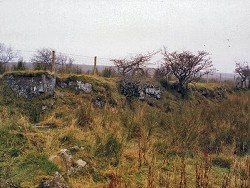
The exposures at Shanvin include the stratotype section for the Skea Sandstone Member and an excellent illustrative outcrop of the Ederny Limestone Member. | |
| Description: | |
The stratotype section of the Skea Sandstone Member at Shanvin is located 150m east of the B72 Ederny - Castlederg Road, 10km NNE of Kesh. Exposures occur in a linear pattern NE and SW of the ruined farm buildings (H2121 7336) but consist mainly of limestones of the Ederny Member of the Ballyshannon Limestone Formation. The main exposure of the Skea Sandstone Member forms a low scarp, inclined at 18 deg. to the SE, some 15m east of the farmhouse and extends southwestwards beneath the new field boundary fence and relict thorn hedge. About 2.2m of coarse- grained and gritty fawn sandstone forms this low feature. 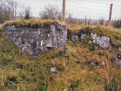 Southeast of the low sandstone feature, the top bedding surface of the Skea Member slopes down to a small rivulet in the adjacent SW-trending valley. Exposures in the rivulet are of grey-brown micaceous siltstones and mudstones with thin beds of hard, parallel laminated calcareous sandstones and represent the basal beds of the Bundoran Shale Formation, above the Skea Sandstone Member. | |
| Interpretation: | |
The Skea Sandstone Member in the stratotype section at Shanvin is formed largely of non-conglomeratic sandstones with a gritty basal layer that is very reminiscent of the lithologies that occur at Drummahon Lane (Key Site 230). | |
| Conclusions: | |
In addition to the exposures of sandstone that form the natural scarp feature at Shanvin, it is possible, in temporary excavations, to expose the contact between the sandstone and the underlying limestone at this locality. Excellent exposures of the Ederny Member form a prominent ridge both south, and NE of the ruined farmhouse. | |
| Notes: | |
For information on other sites in Subarea-3 see; Key Site 1176 - Subarea-3; Kesh-Omagh. | |
| Keywords | |
|---|---|
| Rocks: | Limestone, Sand, Sandstone |
| Relations: | Marine sediments |
| Access | |
|---|---|
| Approach: | 150m east of the B72 Ederny - Castlederg Road, 10km NNE of Kesh. |
| Record type: | ESCR report | ||
| Entered by: | Doughty, P.J. | ||
| Enlander, I., Dempster, M. & Doughty, P., 2026. Shanvin, County Tyrone, site details. [In] Earth Science Conservation Review. https://www.habitas.org.uk/escr/site.php?item=229. Accessed on 2026-11-08. |
| Previous Site | Next Site |