
| Previous Site | Next Site |
Earth Science Conservation Review
| Killygarry River | Fermanagh |
| Site number: | 238 | File Number: | H26 |
| ESCC: | EO | ||
| Locality Type: | Stream section | Status: | ESCR |
| Grid Reference: | H2066 End(s) of linear site | ||
| Google maps: | 54.54241,-7.69096 | ||
| County: | Fermanagh | Council area: | Fermanagh & Omagh District Council |
| Period: | Carboniferous | ||
| Stages: | Arundian, Holkerian, Visean | ||
| Lithostrat: | Benbulben Shale Formation, Drumchorick Siltstone Formation, Tyrone Group | ||
| Site Description | |
|---|---|
 | |
| Highlights: | |
Long sections of both formations and the contact between them are exposed in this river. The stratotype of the Drumchorick Siltstone Formation is located at the north end of the section. | |
| Description: | |
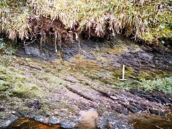
The Killygarry river section is located just over 4km NE of Kesh. The section of the river is located between the townlands of Drumkeeran, in the west and Drummacahan and Killygarry in the east. Exposures of the Drumchorick Siltstone Formation commence at the prominent waterfall (H2060 6709) at the north end of the section. Strata in this section are inclined at between 15-30 deg. to the south and SW. The limestone bed of the fallmaker is 0.7m thick and consists of dark grey, very fine-grained sandstone and sandy packstone in the basal 0.1m of the bed. The river channel cuts through this bed, at the waterfall, along the plane of a small NE-SW orientated normal fault with a downthrow of 1.5m to the NW. The lenticular and thin-bedded nature of strata in this formation is well displayed below this thick bed in the west bank of the river. Thin limestone beds above and below the main fallmaker bed weather out from the enclosing siltstone and mudstones. The limestone contain the packed and normally graded debris of crinoid ossicles and erode into the underlying argillaceous sediments. The top of the Drumchorick Siltstone and contact with the succeeding Benbulben Shale is exposed in the SW bank (H2077 6688) of the river 270m SE of the waterfall. Thick sandy and silty limestones occur at the top of the Drumchorick Siltstone and are overlain downstream by a sequence consisting dominantly of dark grey silty mudstones with occasional beds, up to 0.4m thick of pale orange-brown weathering, coralliferous limestones. These are ovelain by typical dark grey mudstones of the Benbulben Shale in a section (H2096 6674) on the east bank of the river. The north end of this exposure is marked by a NE-SW trending 1m wide basalt (Palaeogene) dyke. South of the dyke are exposed about 5m of strata, consisting mainly of dark grey-brown calcareous mudstones of the Benbulben Shale Formation. 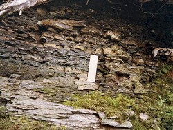 Southwest of this exposure the Benbulben Shale is well exposed in the bed and banks of the river to the end of the section at H2069 6650. Thin fossiliferous limestones occur throughout the mudstones but colonies of Siphonodendron and laminae of coral debris are confined to the SW end of the section. | |
| Interpretation: | |
The transitional nature of sediments at the contact between the Drumchorick Siltstone and Benbulben Shale formations is described in the section relating to the former formation in the Subarea-3 general report (Key Site 1176). Regarding the age of the Benbulben Shale, elsewhere in NW Ireland there is ample evidence for an Asbian age in the upper part of the formation and limited evidence for an Holkerian age in lower parts. The Kesh-Omagh area now provides incontrevertible evidence that the basal few metres of the Benbulben Shale is Arundian. However no data are yet available to indicate an Asbian age at any level in this formation in Subarea-3 and at present the youngest part of the Benbulben Shale is at least Holkerian in age. | |
| Conclusions: | |
The stratotype section of the Drumchorick Siltstone in the Killygarry river exposes the contact between this formation and the succeeding Benbulben Shale. Long sections in the Benbulben Shale shows it to consist primarily of dark grey mudstones and thin limestones. | |
| Notes: | |
For information on other sites in Subarea-3 see; Key Site 1176 - Subarea-3; Kesh-Omagh. | |
| Keywords | |
|---|---|
| Rocks: | Limestone, Mudstone |
| Fossil Groups: | Coral, Crinoid |
| Fossil List: | Siphonodendron sp. |
| Relations: | Marine sediments |
| Access | |
|---|---|
| Approach: | Just over 4km NE of Kesh. |
| Map(s): | See 1:50,000 O.S. Sheet 17 (Lower Lough Erne). | ||
| Record type: | ESCR report | ||
| Entered by: | Doughty, P.J. | ||
| Enlander, I., Dempster, M. & Doughty, P., 2026. Killygarry River, County Fermanagh, site details. [In] Earth Science Conservation Review. https://www.habitas.org.uk/escr/site.php?item=238. Accessed on 2026-11-06. |
| Previous Site | Next Site |