
| Previous Site | Next Site |
Earth Science Conservation Review
| Drummond Quarry, Aughnacloy | Tyrone |
| Site number: | 252 | File Number: | H65 |
| ESCC: | ED | ||
| Locality Type: | Quarry (disused) | Status: | ASSI |
| Grid Reference: | H690519 Centroid | ||
| Google maps: | 54.41146,-6.93727 | ||
| County: | Tyrone | Council area: | Mid Ulster District Council |
| Period: | Carboniferous | ||
| Stages: | Arundian, Visean | ||
| Lithostrat: | Bundoran Shale Formation, Tyrone Group | ||
| Site Description | |
|---|---|
 | |
| Highlights: | |
In Northern Ireland this is the only known quarry that is excavated solely in the Bundoran Shale Formation. Drummond Quarry is also the most easterly outcrop of this formation. | |
| Description: | |
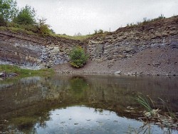
Drummond Quarry is located on the east side of the C-class road between Crilly and Glencrew, 2.5km ESE of Aughnacloy. The quarry is flooded but all faces are still accessible along a steeply sloping bank of shale debris that fringes the base of the 4-6m high face. About 8m of strata are exposed in the quarry and are inclined northwards at up to 20 deg. With the exception of very occasional, thin beds of bioclastic limestone the remainder of the strata in the quarry consist of medium to dark grey mudstone and silty mudstone. Within this definition are two contrasting lithologies that occur in almost equal thicknesses. Thin to thick beds of hard, very calcareous, silty mudstone, bear a superficial resemblance to limestones and are interbedded with softer, blue-grey less calcareous and fissile mudstones. 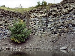 Fossils are abundant in the quarry and in the roadside cutting, 80m NW of the quarry. The fauna includes the following forms: Solitary corals: Siphonophyllia garwoodi Colonial corals: Diphyphyllum sp. Michelinia megastoma Siphonodendron martini Brachiopods: Antiquatonia sp. Buxtonia sp. Echinoconchus sp. Pustula pyxidiformis P. cf. rugata Rugosochonetes sp. Schizophoria sp. Spirifer sp. Syringothyris elongata The coral assemblage of S. garwoodi, M. megastoma and S. martini is indicative of an Arundian age and in particular is consistent with a correlation with the mid-Arundian 'Arnside Fauna' of Garwood (1907), from south Cumbria. | |
| Interpretation: | |
The geology of the eastern part (Aughnacloy-Tynan) of Subarea-5 (1:50,000 Sheet 46 - Clogher) is confused by a proliferation of lithostratigraphical names and erroneous correlations. The oldest rocks that occur in this area, south of the Clogher Valley Fault, are of mid-Arundian age and undoubtedly belong to the Bundoran Shale Formation. The best exposure of these strata is in Drummond Quarry and indeed this quarry is unique in Subarea-5 and in the whole of N. Ireland, being the only one that is known to be excavated solely in this formation. In terms of the palaeogeography of the Northwest Carboniferous Basin in Arundian times this quarry provides evidence of the extent of deposition of these sedimentary rocks outside the main formation outcrop in Co. Fermanagh (Subareas 1 & 2). Given the apparent absence of this formation in the main (western) part of the Clogher Valley in the NE part of Subarea-2 and the western part of Subarea-5 (GSNI, 1982, 1:50,000 Sheet 45), Drummond Quarry occurs within a fault-bounded ? inlier, located at least 30km NE of the nearest exposures in the Newtownbutler area (Subarea-2) and 50km east of the outcrop in the Derrygonnelly area (Subarea-1). This inlier must however be located close to the margin of the mid-Arundian shale basin because there are no representatives of the Bundoran Shale at Armagh (Subarea-6), 20km to the ESE. | |
| Conclusions: | |
Drummond Quarry is a unique locality in N. Ireland. It is the only known quarry that is excavated solely in the Bundoran Shale Formation and yields a shelly fauna that is diagnostic of age and typical of the formation. | |
| Notes: | |
For information on other sites in Subarea-5 see; Key Site 1178 - Subarea-5; Clogher-Aughnacloy. | |
| Keywords | |
|---|---|
| Rocks: | Mudstone |
| Fossil Groups: | Brachiopod, Coral |
| Fossil List: | Michelinia megastoma , Pustula pyxidiformis , Siphonodendron martini , Siphonophyllia garwoodi , Syringothyris elongata |
| Relations: | Marine sediments |
| Measurements | |||||
|---|---|---|---|---|---|
| Length: | Width: | Height: | ~8 m | ||
| Depth: | Area: | ||||
| Access | |
|---|---|
| Approach: | Drummond Quarry is located on the east side of the C-class road between Crilly and Glencrew, 2.5km ESE of Aughnacloy. |
| References (1) | |||
|---|---|---|---|
| Garwood, E.J., 1907. Notes and faunal succession in the Carboniferous Limestone of Westmoreland and neighbouring areas. Geological Magazine, vol. 44, pp.70-74. | |||
| Map(s): | GSNI 1:50,000 Solid Geology of Sheet 46 (Clogher). | ||
| Record type: | ESCR report | ||
| Entered by: | Doughty, P.J. | ||
| Last updated: | 8 Jan 2005 | ||
| Enlander, I., Dempster, M. & Doughty, P., 2026. Drummond Quarry, Aughnacloy, County Tyrone, site details. [In] Earth Science Conservation Review. https://www.habitas.org.uk/escr/site.php?item=252. Accessed on 2026-11-06. |
| Previous Site | Next Site |