
| Previous Site | Next Site |
Earth Science Conservation Review
| Drumarg - Carboniferous | Armagh |
| Site number: | 275 | File Number: | H84 |
| ESCC: | EO | ||
| Locality Type: | Cliff | Status: | ASSI |
| Grid Reference: | H86774409,H86904392 End(s) of linear site, Not Entered | ||
| Google maps: | 54.3378,-6.66704 | ||
| County: | Armagh | Council area: | Armagh City, Banbridge & Craigavon Borough Council |
| Period: | Carboniferous | ||
| Stages: | Asbian, Visean | ||
| Lithostrat: | Armagh Group | ||
| Site Description | |
|---|---|
 | |
| Highlights: | |
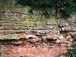
The occurrence of shallow water limestones is common in the Asbian part of the Armagh Group. Frequent subaerial exposure of the sea bed led to the formation of pedogenic horizons with distinctive effects on the normal limestone-shale sequence. | |
| Description: | |
The cliff section in Drumarg Townland extends from the southern side of the A28 Armagh-Killylea road at H8677 4409, southeastward for over 200m along the edge of a field boundary to H8690 4392. A total thickness of ~10m of strata are exposed in the cliff, dipping NE and north at between 5-11 deg. with the youngest beds occurring at the NW end of the section. The lowest beds in the section comprise about 2.25m of medium grey, medium to coarse-grained packstones/grainstones with laminae of purple-grey calcareous shale. Lying above them are some 4.4m of thickly bedded, medium grey fine-grained packstones with thin horizons showing pedogenic brecciation of limestone beds and reddening of the enclosing shales. The thickest bed of shales and limestones showing the pronounced effects of exposure and pedogenesis is 0.9m thick and occurs at the base of the cliff face at the NW end of the section. 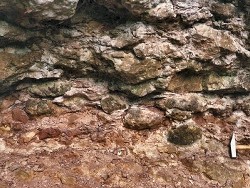 Despite the intense disruption of the limestone-shale sequence by the processes of pedogenesis, karstification and subaerial exposure, the fossiliferous nature of the original (marine) limestones is still evident and the following brachiopods and corals are recorded: BRACHIOPODS:Echinoconchus sp., Gigantoproductus sp., Megachonetes sp., Schizophoria sp. CORALS: Siphonodendron junceum, S. pauciradiale. | |
| Interpretation: | |
The Asbian strata exposed at Rock Road Quarry, Drumarg Cliff and Annacramph Lane are representative of the limestones that typify the Asbian section of the Armagh Group. Their association with unusual lithologies, accumulations of fossils and sedimentary structures, that are found at all three localities, are unique or extremely rarely exposed in outcrop. Their significance is however considerable in that they all signify shallow water conditions, during Asbian times, accompanied by emergence of the sea bed, erosion of contemporaneous sediments and proximity of a land area from which clastic sediment was transported into an environment in which marine limestones were usually accumulating. Very little can be said, either about the areal extent of these palaeokarst surfaces, limestone conglomerates or rare sandstone beds and there are few data concerning their frequency in the Asbian succession in the Armagh Group in Subarea-6. | |
| Conclusions: | |
The unusual lithologies that occur at Drumarg Cliff are very rare in the Armagh Group. As far as can be determined they originated as a result of the effects of pedogenesis and karstification on freshly exposed limestones. The development of palaeokarst surfaces and sandstone bodies of Asbian age in the Armagh Group reaches its acme in the Cookstown area (Subarea-7; Key Site 1180). | |
| Notes: | |
For information on other sites in Subarea-6 see Key Site 1179 - Subarea-6; Armagh-Benburb. | |
| Keywords | |
|---|---|
| Rocks: | Limestone, Shale |
| Fossil Groups: | Brachiopod, Coral |
| Fossil List: | Echinoconchus sp. , Gigantoproductus sp. , Megachonetes sp. , Schizophoria sp. , Siphonodendron pauciradiale |
| Structures: | palaeokarst |
| Relations: | Marine sediments |
| Measurements | |||||
|---|---|---|---|---|---|
| Length: | >200 m | Width: | Height: | up to 10 m | |
| Depth: | Area: | ||||
| Access | |
|---|---|
| Approach: | The cliff section extends from the southern side of the A28 Armagh-Killylea road southeastwards for over 200m along a field boundary. |
| Map(s): | See 1:50,000 O.S. Sheet 19 (Armagh). | ||
| Record type: | ESCR report | ||
| Entered by: | Doughty, P.J. | ||
| Last updated: | 8 Jan 2005 | ||
| Enlander, I., Dempster, M. & Doughty, P., 2026. Drumarg - Carboniferous, County Armagh, site details. [In] Earth Science Conservation Review. https://www.habitas.org.uk/escr/site.php?item=275. Accessed on 2026-11-06. |
| Previous Site | Next Site |