
| Previous Site | Next Site |
Earth Science Conservation Review
| Drumarg | Armagh |
| Site number: | 1196 | ||
| ESCC: | EO | ||
| Locality Type: | Cliff, Inland exposure, Low cliff | Status: | ESCR |
| Grid Reference: | H871439 Centroid | ||
| Google maps: | 54.33684,-6.66092 | ||
| County: | Armagh | Council area: | Armagh City, Banbridge & Craigavon Borough Council |
| Period: | Permian | ||
| Stages: | Lower Permian | ||
| Lithostrat: | Basal Permian Breccia, Callan Group, Drumarg Conglomerate Formation | ||
| Site Description | |
|---|---|
 | |
| Highlights: | |
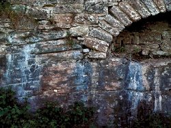
The outcrop of Permian rocks at Drumarg is the most westerly occurrence in Northern Ireland and is the best example of exposed Basal Permian Breccias. It is the stratotype for the Drumarg Conglomerate Formation. | |
| Introduction: | |
The only exposure of the Drumarg Conglomerate Formation is in Drumarg townland, below the wall on the west side of the Rock Road, 1.3km SSW of Armagh Cathedral. The geology of the Permian strata around Armagh City has been described by Egan (1873) and studied by Mitchell (pers. comm.). Egan described the section at Drumarg but the published map (GSI, 1873) also included outcrops along the Callan River and at Benburb which have since been interpreted as Triassic conglomerates. Rocks of Permian age are thought to be restricted to the small outlier underlying Armagh City. Most of the outcrops recorded by Egan are now concealed by urban development. The detailed geological information has been gathered from the notes of Hartley. The most valuable aspect of his work was in collating data from the records of boreholes completed as far back as 1911. The Permian strata have an estimated thickness of about 52m and locally are termed the Callan Group which has been divided into two formations. The Drumarg Conglomerate Formation at the base and the Dobbin Sandstone Formation below the Mall Member are considered to correlate with the Enler Group, while the Mall Member and the overlying part of the Dobbin Sandstone Formation correlate with the Belfast Group. Only the conglomerates are seen in outcrop with additional information from boreholes. | |
| Description: | |
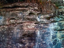
Exposed as a low cliff face below the west side of Rock Road near the southern end of the Drumarg Housing Estate, at least 3.45m of flaggy bedded conglomerate dip to the NE at ~6 deg. Clasts are usually of subangular to sub-rounded pieces of pale pink to grey micrite or white bio-oopelsparite limestone which occur in massive beds just below the unconformity.
 | |
| Importance: | |
The site is of national importance as the best exposure of the Basal Permian Breccia and the stratotype for the Lower Permian Drumarg Conglomerate Formation. The presence of Permian strata in the Armagh area allows improved palaeogeographic reconstruction. | |
| Interpretation: | |
The age of the red-bed sequence at Armagh has been the subject of debate. Egan concluded that some of the sequence is Triassic but Mitchell mapped only a very small area of Triassic strata. These basal conglomerates are shown to lie beneath Magnesian Limestone in boreholes. The dating of the limestone in Co. Tyrone, and elsewhere, allows a Lower Permian age to be attributed to these conglomerates. | |
| Conclusions: | |
The outcrop of Permian strata at Drumarg is the best exposure of Lower Permian Breccias and it is of national significance. It is the most westerly occurrence of these rocks in Ireland and should be conserved. | |
| Notes: | |
For information on other Permian sites see Key Site 17 - Cultra Key Site 1195 - Ballyrainey. For general information on the Permian System in N. Ireland see Key Site 1191 - The Permian System in N. Ireland - Introduction. | |
| Keywords | |
|---|---|
| Rocks: | Breccia, Conglomeratic sandstone, Sand, Sandstone |
| Measurements | |||||
|---|---|---|---|---|---|
| Length: | Width: | Height: | 3.45 m+ | ||
| Depth: | Area: | ||||
| Access | |
|---|---|
| Approach: | The west side of the Rock Road, 1.3km SSW of Armagh Cathedral. Access to the site is from Rock Road via a farm gate. |
| Management: | |
Situated at the edge of a field and below a road, the main danger to the site would be an extension of urban development, road widening or indiscriminate dumping. | |
| References (1) | |||
|---|---|---|---|
| Egan, F.W., 1873. Explanatory memoir to accompany Sheet 47 of the maps of the Geological Survey of Ireland, including the country around Armagh. Memoirs of the Geological Survey of Ireland, Dublin. | |||
| Map(s): | Geological Survey of Ireland (1873) 1:63,360 Geological Sheet 47 (Armagh). | ||
| Record type: | ESCR report | ||
| Entered by: | E M Porter | ||
| Last updated: | 8 Jan 2005 | ||
| Enlander, I., Dempster, M. & Doughty, P., 2026. Drumarg, County Armagh, site details. [In] Earth Science Conservation Review. https://www.habitas.org.uk/escr/site.php?item=1196. Accessed on 2026-11-06. |
| Previous Site | Next Site |