
| Previous Site | Next Site |
Earth Science Conservation Review
| Port Obe, Cushendall | Antrim |
| Site number: | 309 | File Number: | D22 |
| ESCC: | EF | ||
| Locality Type: | Coastal section | Status: | ESCR |
| Grid Reference: | D24702882 Centroid | ||
| Google maps: | 55.09125,-6.04686 | ||
| County: | Antrim | Council area: | Causeway Coast & Glens Borough Council |
| Period: | Devonian | ||
| Stages: | Lower Devonian | ||
| Lithostrat: | Ballyagan Formation, Cross Slieve Group, Cushendall Formation | ||
| Site Description | |
|---|---|
 | |
| Description: | |
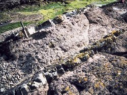
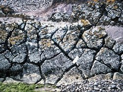
Exposures of the Ballyagan Formation occur on the beach at Port Obe where the small river draining this steep gully emerges onto the beach. The beds dip seawards at about 40 deg. and are exposed in 2 ridges protruding through the shingle and thin sand cover. The rocks consist of lilac to purple-red coarse to medium-grained sandstones with low angle cross-bedding and parallel laminations. At the top of each low ridge is a 15cm thick bed of hard, pale green mudstone whose top surface shows a development of large scale desiccation cracks that are infilled with coarse sandstone from the succeeding bed.
 Some 50m east of these exposures is a craggy 'island' composed of very coarse conglomerate containing mostly igneous debris that represents the basal beds of the succeeding Cushendall Formation. On the north side of Port Obe are low cliffs in which the bedding is inclined seawards and the rocks consist exclusively of coarse pink sandstones of the Ballyagan Formation. Cross-stratification on a large scale is evident in these exposures. 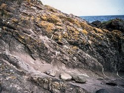 The basal beds of the Cushendall Formation are also exposed some 450m to the north-northeast. Here they consist of very coarse, poorly sorted breccio-conglomerates with a maximum clast size of up to 1m, and a clast component dominated by intermediate volcanic igneous debris of dacitic composition. 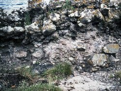 | |
| Notes: | |
For general information and reference list on the Cross Slieve Group see Key Site 1146 - Cross Slieve Group; Cushendun to Port Obe. For general information and reference list on the Devonian System in N. Ireland see Key Site 1147 - The Devonian System in N. Ireland - Introduction. | |
| Keywords | |
|---|---|
| Rocks: | Conglomerate, Mudstone, Sand, Sandstone |
| Structures: | cross-bedding, dessication cracks |
| Map(s): | See the 1:50,000 O.S. Sheet 5 (Ballycastle). | ||
| Record type: | Environment Serv. GIS, ESCR report | ||
| Entered by: | Doughty, P.J. | ||
| Enlander, I., Dempster, M. & Doughty, P., 2026. Port Obe, Cushendall, County Antrim, site details. [In] Earth Science Conservation Review. https://www.habitas.org.uk/escr/site.php?item=309. Accessed on 2026-11-08. |
| Previous Site | Next Site |