
| Previous Site | Next Site |
Earth Science Conservation Review
| Port Moon (Contham Head) | Antrim |
| Site number: | 1115 | ||
| ESCC: | EC | ||
| Locality Type: | Coastal section | Status: | ASSI |
| Grid Reference: | C978456 Centroid | ||
| Google maps: | 55.24813,-6.46219 | ||
| County: | Antrim | Council area: | Causeway Coast & Glens Borough Council |
| Period: | Tertiary | ||
| Stages: | Eocene, Palaeocene | ||
| Lithostrat: | Antrim Lava Group, Lower Basalt Formation | ||
| Site Description | |
|---|---|
 | |
| Highlights: | |
A remarkable structural feature within the Lower Basalts of the Causeway Coast is probably the only example of a 'lava-tube' among the Antrim Basalts. | |
| Introduction: | |
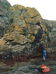
500 m north of Port Moon on the Causeway Coast of Co. Antrim the rock platform at HWM is interrupted by a magmatic roll of basalt lava some 9 m high. Its presence was first noticed by P. Millar of the Belfast Geologist's Society, who through the years has demonstrated the feature to members of the Society. | |
| Description: | |
An isolated mass of basalt rests on the rock platform close to HWM. At its seaward end it attains a height of some 9 m and appears to be the relict of a roll or rod like structure about 9 m in diameter. Only half of the roll is preserved at the seaward end but the feature can be traced inland to the WSW across the rock platform. Concentric joints in the basalt run parallel to the external surface of the roll and are spaced at intervals of circa 20 cms. The base of the roll coincides with the base of a flow which rests on the reddened top of the underlying basalt. | |
| Importance: | |
A unique structural feature among the Antrim basalts, and if the above hypothesis is correct, the only example of its kind as yet exposed in Northern Ireland. | |
| Interpretation: | |
Tomkeieff (1946) first coined the term 'magmatic roll' to describe small scale features in igneous rocks from the Island of Arran, Firth of Clyde. Patterson (1951) adopted the term to explain much larger structures in the quartz trachyte of Glynn Hill, Co. Antrim; though 'lava roll' would have been a more appropriate term for an extrusive feature. Such structures are not uncommon amongst viscous lavas such as trachytes and rhyolites but would be of rare occurrence in the much more mobile basaltic lava flows. Where they do occur the concentric joints are not isolated, as at Port Moon, but are repeated as a fold structure along the base of a flow. When fluid gas-rich lava erupts at the earth's surface to form a pahoehoe flow, the nature of the extrusion is governed, among other factors, by the rate of extrusion. Initially the lava will spread away from the feeding vent on a broad front but even over flat ground there will come a time when the rate of extrusion cannot keep all of the ever expanding front moving. When this happens some of the lava will come to a standstill, pond and congeal; the fresh lava will then be restricted to narrow streams which extend from the feeder to beyond the flow front. These streams will flow beneath a solid crust and will adjust their size to the volume of lava extruded. The hot viscous ponded lava will be readily scoured to accommodate a more voluminous flood or allow the margins of the stream to congeal against the cooler mass of the flow when the supply from the vent wanes. In this way concentric shells of lava can fill the tube-like conduit of the subsurface stream; alternatively fresh lava could scour out the tube diameter, wholly or in part, to larger dimensions. Often the lava runs out of the tube leaving a cavernous opening through the flow - hence the name lava-tube, but at times the conduit can remain full of lava when the flow solidifies. With aa flows the streams move over the surface of the flow, and in the Antrim Lava Series most of the lavas are of aa type with scoriaceous tops. Pahoehoe lava is restricted to the vicinity of the feeding vent and often occurs as thin flow units; good examples of thin flows with ropy surfaces can be found in cliff section around the coast of Co. Antrim. The conditions for tube formation are therefore rare. The Portcoon cave near Runkerry Head is of unusual length and shape for a sea cave and may be the remnants of a lava-tube, its enlarged width near the base could be due to lava scour or to marine erosion. The Port Moon structure however cannot be accounted for by some freak of marine erosion and must be a strong candidate for a filled lava-tube. | |
| Conclusions: | |
Worthy of conservation because of its unique character. | |
| Notes: | |
There are no references to this occurrence in the literature. | |
| Keywords | |
|---|---|
| Rocks: | Basalt, Pahoehoe |
| Structures: | lava-tube, magmatic roll |
| Relations: | Extrusion |
| Measurements | |||||
|---|---|---|---|---|---|
| Length: | Width: | Height: | 9 m | ||
| Depth: | Area: | ||||
| Access | |
|---|---|
| Approach: | Access is difficult and somewhat dangerous. A grassy track leads down the cliff just N of the path descending to the fishing station at Port Moon. About a third the way down, the path has slipped over a precipitous cliff. If this can be negotiated the track then turns towards an old iron mine adit in the Interbasaltic laterite, and finally descends down the grassy scree to the shore. Tide permitting, a climb onto the raised rock platform allows a view of the feature from the south. |
| References (3) | |||
|---|---|---|---|
| Macdonald, G.A., 1972. Volcanoes, pp.510 PP., New Jersey. | |||
| Patterson, E.M., 1951. An occurrence of Quartz-trachyte among the Tertiary basalt lavas of North-East Ireland Proceedings of the Royal Irish Academy, vol. 53 pt. B, pp.265-287. | |||
| Tomkeieff, S.I., 1946. Magmatic Rolls Nature, vol. 158, pp.420. | |||
| Map(s): | For site location see the 1:50,000 O.S. Sheet 5 (Ballycastle). | ||
| Record type: | ESCR report | ||
| Entered by: | E M Porter | ||
| Enlander, I., Dempster, M. & Doughty, P., 2026. Port Moon (Contham Head), County Antrim, site details. [In] Earth Science Conservation Review. https://www.habitas.org.uk/escr/site.php?item=1115. Accessed on 2026-11-08. |
| Previous Site | Next Site |