
| Previous Site | Next Site |
Earth Science Conservation Review
| Glasmullen Townland stream | Antrim |
| Site number: | 314 | File Number: | D22 |
| ESCC: | EO | ||
| Locality Type: | Stream section | Status: | ASSI |
| Grid Reference: | D22052242 Centroid | ||
| Google maps: | 55.03447,-6.09186 | ||
| County: | Antrim | Council area: | Causeway Coast & Glens Borough Council |
| Period: | Devonian | ||
| Stages: | Upper Devonian | ||
| Lithostrat: | Red Arch Formation | ||
| Site Description | |
|---|---|
 | |
| Description: | |
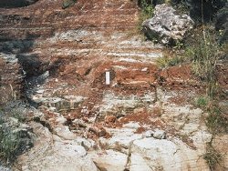
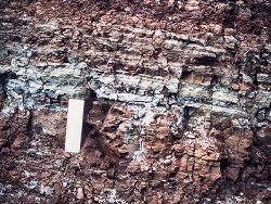
The highest beds of Unit 5 of the Red Arch Formation are exposed in a stream section on the west side of Glenariff on the north flank of the abandoned chalk quarry in Glasmullen Townland, 4.3km southwest of the Red Arch. The lowest beds are white to pale-fawn, medium-grained, cross-stratified sandstones with thin beds of brown-red mudstone. Lying above the sandstones and succeeding them abruptly and conformably are thick red-brown laminated mudstones and pedogenic mudstones with carbonate nodules. Laminae of green mudstone occur throughout the 3-4m of mudstone exposed and near their base is one section about 12cm thick composed entirely of banded dark and light green mudstone.
 | |
| Notes: | |
For general information and reference list on the Red Arch Formation see Key Site 1148 - Red Arch Formation; Cushendall to Red Arch, Glenariff. For general information and reference list on the Devonian System in N. Ireland see Key Site 1147 - The Devonian System in N. Ireland - Introduction. | |
| Keywords | |
|---|---|
| Rocks: | Mudstone, Sand, Sandstone |
| Structures: | cross-bedding |
| Map(s): | See the 1:50,000 O.S. Sheet 9 (Ballymena, Larne). | ||
| Record type: | Environment Serv. GIS, ESCR report | ||
| Entered by: | Doughty, P.J. | ||
| Enlander, I., Dempster, M. & Doughty, P., 2026. Glasmullen Townland stream, County Antrim, site details. [In] Earth Science Conservation Review. https://www.habitas.org.uk/escr/site.php?item=314. Accessed on 2026-11-06. |
| Previous Site | Next Site |