
| Previous Site | Next Site |
Earth Science Conservation Review
| Drumharvey Townland quarry | Tyrone |
| Site number: | 316 | File Number: | H26 |
| ESCC: | ED | ||
| Locality Type: | Quarry (disused) | Status: | ASSI |
| Grid Reference: | H250604 Centroid | ||
| Google maps: | 54.49188,-7.61419 | ||
| County: | Tyrone | Council area: | Fermanagh & Omagh District Council |
| Period: | Devonian | ||
| Stages: | Famennian, Frasnian | ||
| Lithostrat: | Fintona Group, Shanmullagh Formation (Form Blm) | ||
| Site Description | |
|---|---|
 | |
| Description: | |
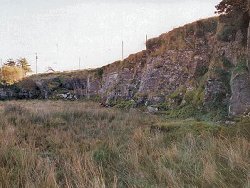
About 10m of hard purple-brown, fine to medium-grained feldspathic sandstones are exposed in the stratotype quarry, dipping southwest at 6 deg. There are no major bedding surfaces in the quarry but all the rocks are laminated, the laminae being defined by grain size variation in the sandstones, increasing amounts of silt grade sediment and especially by thin, ripple laminated layers of chocolate-brown mudstone. None of the sandstones are coarse-grained but many of them contain a scattering of coarse, angular grains of quartz. In this quarry the sandstones have non-erosive bases but almost all contain small clasts of brown mudstone which probably originated by desiccation and fragmentation of these layers. Ripple marks are very common in the sandstones but are only well exposed in the yard of the bungalow located above the top of the quarry at H25046033. There three separate bedding surfaces on purple-brown, fine-grained calcareous sandstone show asymmetrical ripples indicating currents flowing to the west-northwest in 2 examples and to the north in the other case. On the floor of the quarry ripples indicate current flow to the east. | |
| Notes: | |
For general information and reference list on the Shanmullagh Formation with respect to stratotype see Key Site 1150 - Shanmullagh Formation; Stratotype localities. For general information and reference list on the Shanmullagh Formation with respect to miospore localities see Key Site 1151 - Shanmullagh Formation; Miospore localities. For general information and reference list on the Devonian System in N. Ireland see Key Site 1147 - The Devonian System in N. Ireland - Introduction. | |
| Keywords | |
|---|---|
| Rocks: | Mudstone, Sand, Sandstone |
| Structures: | ripple marks |
| Map(s): | GSNI (1982a) 1:50,000 Sheet 45 (Enniskillen); GSNI (1982b) 1:50,000 Sheet 46 (Clogher); O.S. 1:50,000 Sheet 18 (Enniskillen). | ||
| Record type: | Environment Serv. GIS, ESCR report | ||
| Entered by: | Doughty, P.J. | ||
| Enlander, I., Dempster, M. & Doughty, P., 2026. Drumharvey Townland quarry, County Tyrone, site details. [In] Earth Science Conservation Review. https://www.habitas.org.uk/escr/site.php?item=316. Accessed on 2026-11-06. |
| Previous Site | Next Site |