
| Previous Site | Next Site |
Earth Science Conservation Review
| Mournes - Spelga Dam | Down |
| Site number: | 1114 | ||
| ESCC: | EO | ||
| Locality Type: | Stream section | Status: | ASSI |
| Grid Reference: | J265273 Centroid | ||
| Google maps: | 54.17955,-6.06252 | ||
| County: | Down | Council area: | Newry, Mourne & Down District Council |
| Period: | Tertiary, Silurian | ||
| Stages: | Eocene, Silurian Undifferentiated | ||
| Lithostrat: | Granite | ||
| Site Description | |
|---|---|
 | |
| Highlights: | |
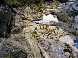
An unusual and fine example of stoping at a granite - wall-rock contact. | |
| Introduction: | |
Emeleus (1955) and later Gibson (1984) remapped the Western Mournes and added detailed comment to Richey's earlier work (1928). Emeleus's revision was made prior to the construction of the Spelga Dam which has obscured part of the G4 / Silurian contact. | |
| Description: | |
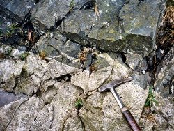
Both G4 and G5 granites of the Western Mournes are interpreted as ring-dyke intrusions by Emeleus (1955). The dome shaped roof of G4 bulges northeastwards towards Spelga and in the stream section downstream of the Dam an angular, irregular granite dyke penetrates the Silurian hornfels.
 | |
| Importance: | |
A typical marginal contact around the dome of G4 which points to the beginning of granite emplacement by stoping subsequent to ring-dyke emplacement. | |
| Interpretation: | |
Although the two granites of the Western Mournes are considered the consequence of cauldron subsidence and ring-dyke intrusion (Emeleus, 1955) the walls of the ring-dykes are not exposed at the present level of erosion. Only the laccolithic tops, occupying cross fractures above the subsided blocks, can be examined. Absence of shouldering stresses and deformation in the roof rocks and a lack of xenoliths support this view. The stoping that can be seen is of a limited nature and does not reflect such an emplacement mechanism for the granite mass as a whole. | |
| Conclusions: | |
The concrete of the dam now covers part of the original site. Exposure of what remains will depend on the overflow from the reservoir. | |
| Notes: | |
For Mourne Granites general information and reference list see; Key Site 1129 - The Granites - Overview. For general information on the cone-sheet intrusions associated with the Mourne Granites, and the Mourne Mountain dyke swarm, see; Key site 1131 - Cone-sheet and Dyke Swarm - Overview. | |
| Keywords | |
|---|---|
| Rocks: | Granite, Hornfels |
| Structures: | stoping |
| Relations: | Contact, Intrusion |
| NonGeol: | Private ground secured by the Water Authority |
| Access | |
|---|---|
| Approach: | Access is made via the track to the reservoir. Site is located just below the Spelga Dam. |
| Restrictions: | Access would have to be obtained from the Water Authority and is subject to overflow. |
| Threats: | A small stream would obscure the granite/ Silurian contacts. |
| Map(s): | For geology, see Emeleus (1955). The stream section is readily located on the O.S. Outdoor Pursuits Map of Mourne Country, Irish Grid Ref. J265273. | ||
| Record type: | ESCR report | ||
| Entered by: | E M Porter | ||
| Enlander, I., Dempster, M. & Doughty, P., 2026. Mournes - Spelga Dam, County Down, site details. [In] Earth Science Conservation Review. https://www.habitas.org.uk/escr/site.php?item=1114. Accessed on 2026-11-06. |
| Previous Site | Next Site |