
| Previous Site | Next Site |
Earth Science Conservation Review
| Scrabo Hill - Palaeogene | Down |
| Site number: | 1117 | ||
| ESCC: | ED | ||
| Locality Type: | Quarry (disused) | Status: | ASSI |
| Grid Reference: | J479725 Centroid | ||
| Google maps: | 54.57957,-5.71256 | ||
| County: | Down | Council area: | Ards & North Down Borough Council |
| Period: | Tertiary, Triassic | ||
| Stages: | Eocene, Lower Triassic, Palaeocene | ||
| Lithostrat: | Sherwood Sandstone Group | ||
| Site Description | |
|---|---|
 | |
| Highlights: | |
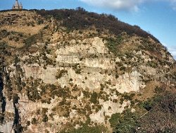
The Triassic Sandstone of Scrabo Hill hosts a number of Tertiary volcanic features. A capping sill of dolerite protected the sandstone from glacial erosion preserving it as a conspicuous crag and tail, Charlesworth (1939). Volcanic vents and dykes are associated with this phase of intrusive activity. | |
| Introduction: | |
The Triassic (New Red/Bunter) sandstone, now referred to as the Sherwood Sandstone Group, of Scrabo Hill is described in detail by Reynolds (1928) and by Smith et al (1991). Quarrying offers good sections through the group especially in the South Quarry. During Tertiary times, olivine basaltic magma invaded the Triassic sandstones. A complex of sill intrusions is the most conspicuous feature and visible in all of the quarry sections around the hill. Basaltic dykes, volcanic vents, and tuff dykes can be seen in the South Quarry. Volcanic exhalations have left mineral veneers on some of the sandstone joints and the bedrock has been discoloured by the volcanic activity. | |
| Description: | |
The Sherwood Sandstones are typically red-brown in colour, the thicker beds, circa 1 m thick, are commonly graded from medium-grained at the base to finer-grained and laminated towards the top. The sand grains are mostly quartz, 0.05-2.0 mm dia., with some 40% feldspar. Micas, zircons, tourmaline and staurolite are present in minor amounts and indicate an origin from a northerly source. Iron oxides act as a weak cement, strengthened in places by calcite. Planar cross-bedding structures are common. Linguoid and rectalinear ripples, sometimes draped with mud, indicate a shallow-water depositional environment; conditions that occasionally preserved trace fossils such as the vertibrate footprint of Chirotherium lomasi and burrows of shrimp and worm, see Ashley (1946) and Swinton (1960). Red-brown mudstone interbeds occur; some show polygonal mudcrack patterns, the cracks often filled with sand; some are rain pitted - products of subaerial dessication; clay galls ripped off these layers litter the sandstone beds. In early Tertiary times basaltic magma invaded the sandstone formation; a capping sill of olivine dolerite 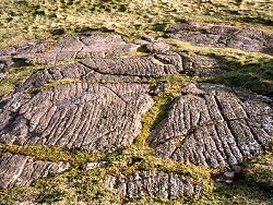 In the South Quarry more unusual volcanic features are exposed, Preston (1968); the most obvious are dark red sandstone breccias, 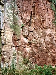 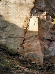 In the top NW corner of the South Quarry the form and fill of a volcanic vent can be found; the sandstone wall-rock is often brecciated, but the vent fill, soft and friable, is composed of sandstone clay and rotten basalt. The clay has been metamorphosed to a felt of amphibole needles; the sandstone is well bleached. No bedding structures are visible in the vent fill. Minor intrusions of dolerite invade and chill against the vent agglomerate. Mineral veneers coat the joint surfaces of the sandstone in the vicinity of these vents. Apatite, sphene, sphalerite, haematite, rutile, tremolite, diopside, and calcite have been recorded. The whole of the sandstone mass of Scrabo Hill is lighter in colour than its normal red-brown appearance. | |
| Importance: | |
This is an excellent locality for demonstrating both sedimentary and volcanic features. The quarry faces offer the best sections through Triassic sandstones accessible in the Province and the volcanic features are clearly displayed. | |
| Interpretation: | |
Structures and textures within the Sherwood Sandstone offer abundant evidence of shallow water deposition (ripple-marks, trace fossils, graded and cross bedding) with intervals of dessication (sun-cracks, rain-pits, foot-prints). Basaltic magma penetrated the formation at depth and volcanic exhalations escaped through the well jointed and porous sandstones. Ground water held within the sandstone probably resulted in phreato-magmatic explosions which drilled vents through the host rock and introduced comminuted sandstone dust into open fissures. Explosive breccias mark the passage of escaping gas and vapour, and the mineral veneers are a possible consequence of this kind of volcanic activity. Sill intrusion followed, since the main vent is obviously truncated and invaded by basalt magma. Sills of great thickness occur at depth within the sandstones in the vicinity of Scrabo Hill; as in the Ballyalton borehole which penetrated some 130 m of dolerite. Surface exposures of dolerite sills occur at Ballyrainey and Dundonald. All these could be closely related to the same access of magma within the Sherwood Sandstone. Migration of magma from depth is a possible mode of emplacement along the bedded structure of the rock, but it could be that basaltic magma established a vent at the Tertiary surface; the explosive structures indicate a relatively shallow depth. Leakage in the wall of this feeder may have allowed magma to drain back into the sandstone, exploiting planes of weakness, and floating the lighter overburden to make room for its lateral extension. Where sandstone became completely engulfed in the magma it suffered a much more intense thermal metamorphism; one such example (Preston 1963) developed tridymite (a high temperature polymorph of quartz) in small orbicular structures throughout the xenolith. Basaltic dykes appear to be the final phase of vulcanism. They are usually 1-3 m thick, vertical, trending NW-SE to N-S. A fine example is left as a remanie mass at the entrance to the South Quarry, and can be traced up through the sandstones and the capping sill. | |
| Conclusions: | |
The whole hill offers sections of great interest to geologists of all kinds, amateurs and professionals, students and research workers. | |
| Notes: | |
Some of the described features are difficult to reach. Disused quarries quickly overgrow and fallen rock and quarry scree soon become hidden under vegetation. Rock falls will augment the available material from time to time; poaching of rock in the South Quarry resulted in overhanging cliffs and subsequent rock falls. There is a dearth of fallen sandstone blocks with exposed bedding planes. Controlled quarrying could be practised in future to provide material from the more inaccessible sections. | |
| Keywords | |
|---|---|
| Rocks: | Dolerite, Sand, Sandstone |
| Products: | Building stone |
| Structures: | breccia, dyke, sill, tuff, volcanic vent |
| Relations: | Intrusion |
| NonGeol: | The area is designated as a Country Park. |
| Access | |
|---|---|
| Approach: | Scrabo Hill lies several miles SW of Newtownards. Access roads and carparks are provided, though much of the hill must be explored on foot. |
| Management: | |
The area is designated as a Country Park. As a result the geological exposures are offered some form of protection. | |
| Threats: | Vegetation- becoming overgrown |
| References (9) | |||
|---|---|---|---|
| Charlesworth, J.K., 1939. Some observations on the glaciation of north-east Ireland Proceedings of the Royal Irish Academy, vol. 45 pt. B, pp.255-295. | |||
| Conybeare, W., 1816. Geological features of north-east Ireland Transactions of the Geological Society of London, vol. 3, pp.121-133. | |||
| Hull, E., Warren, J.L. & Leonard, W.B., 1871. Explanatory memoir to accompany sheets 37, 38 and part of 29 including the country around Bangor, Newtownards, Comber and Saintfield in the County of Down. Memoirs of the Geological Survey of Ireland. | |||
| Lamplugh, G., Kilroe, J.R., M’Henry, A., Seymour, H.J., Wright, W.B. & Muff, H.B., 1904. The Geology of the Country Around Belfast. Memoirs of the Geological Survey of Ireland. | |||
| Preston, J., 1962. Explosive volcanic activity in the Triassic Sandstone of Scrabo Hill, Co. Down Irish Naturalists Journal, vol. 14, pp.45-51. | |||
| Preston, J., 1963. An 'orbicular' quartzite at Scrabo Hill Irish Naturalists Journal, vol. 14, pp.149-153. | |||
| Reynolds, D.L., 1928. The petrography of the Triassic sandstone of north-east Ireland Geological Magazine, vol. 65, pp.448-473. | |||
| Smith, R.A., Johnston, T.P. & Legg, I.C., 1991. Geology of the country around Newtownards Memoirs of the Geological Survey Northern Ireland, pp.42 PP. | |||
| Wilson, H.E., 1972. Regional Geology of Northern Ireland. HMSO, Belfast. | |||
| Map(s): | The 1:50,000 Geological Survey map for Newtownards covers the area. | ||
| Record type: | ESCR report | ||
| Entered by: | E M Porter | ||
| Enlander, I., Dempster, M. & Doughty, P., 2026. Scrabo Hill - Palaeogene, County Down, site details. [In] Earth Science Conservation Review. https://www.habitas.org.uk/escr/site.php?item=1117. Accessed on 2026-11-08. |
| Previous Site | Next Site |