
| Previous Site | Next Site |
Earth Science Conservation Review
| Croagh Mountain - PreCambrian | Fermanagh |
| Site number: | 125 | ||
| ESCC: | EO | ||
| Locality Type: | Crag, Crags, Inland exposure | Status: | ASSI |
| Grid Reference: | G985630 Centroid | ||
| Google maps: | 54.51585,-8.02314 | ||
| County: | Fermanagh | Council area: | Fermanagh & Omagh District Council |
| Period: | Precambrian | ||
| Stages: | Moinian | ||
| Lithostrat: | Lough Derg Group, Slishwood Division | ||
| Site Description | |
|---|---|
 | |
| Highlights: | |
The area around Croagh Mountain contains outcrops displaying a wide variety of lithologies and structures typical of the Lough Derg Group (Slishwood Division). The Lough Derg Group is a series of mainly siliceous granulitic psammitic rocks containing minor semi-pelitic and amphibolite (metabasite) components. | |
| Introduction: | |
Croagh Mountain forms part of the Lough Derg Inlier, an area of Pre-Dalradian basement rocks extending from Lower Lough Erne to Lough Derg. Access to the site is via a partially metalled road and track which passes between Croagh Mountain and Breesy Hill, Co Donegal, or by hiking northwards, across open moorland from Lough Scolban on the Northern Ireland side of the border. On the first edition of the one inch to one mile Geological Map (Sheet 32, Pettigoe, Geological Survey of Ireland, 1885) rocks forming the Lough Derg Inlier were referred to jointly as "gneiss & schist". In the accompanying geological memoir, Symes (1891), and elsewhere Geikie (1891) were first to indicate that the rocks around Lough Derg could be "readily separated from the ordinary metamorphic (Dalradian) of Donegal". Geikie assigned an Archaean age to the Inlier and both he and Symes drew attention to similarities with the "the more ancient gneisses (Lewisian) of the Scottish Highlands". Anderson (1948) was first to suggest a Moinian age for these rocks and followed up with the first detailed account of the stratigraphy, structure and metamorphism of the Lough Derg Inlier. Max et al. (1984) produced a Rb-Sr whole rock isochron indicating an 895+/-60Ma (Grenvillian?) age for the Lough Derg Inlier. They also pointed to similarities between the Lough Derg Inlier and rocks at Rosses Point and parts of the Ox Mountains in the Republic of Ireland. They also introduced the concept of the Slishwood Division to encompass all of this pre-Dalradian basement. The most recently published maps which cover this site include a second 1:50,000 scale edition of Sheet 32 (Kesh, Geological Survey of Northern Ireland, 1994) and the 1:250,000 scale Solid Geology Map of Northern Ireland (Geological Survey of Northern Ireland, 1997). | |
| Description: | |
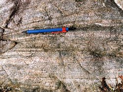
Close to the summit of Croagh Mountain and around the southern and western flanks of this hill, the Lough Derg Group comprises a succession of pale cream to buff coloured medium to coarse-grained siliceous psammites with minor plagioclase, muscovite and biotite. These psammites display a range of granoblastic and cataclastic textures. The succession also contains thin semipelite horizons. The psammite is generally flaggy or more massively bedded and commonly has a variegated striped appearance.
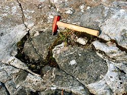 At Croagh Mountain there are a number of fine examples of metabasite (hornblendic epidiorite) intrusives. These are particularly well exposed on the south-eastern slopes of the Mountain where they are mainly in the form of pods and boudinaged masses measuring up to 1m across. 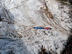 Anderson (1948) described the overall structure of the Lough Derg Inlier as a large open north-easterly plunging antiform (Lough Derg Antiform). The rocks at Croagh Mountain have a dominant regionally consistent NNE-SSW striking foliation which dips at 80°E. At most outcrops there is evidence of intense polyphase deformation and a variety of examples of tight harmonic and disharmonic ductile folds. 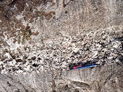 Pegmatite veins occur throughout the Lough Derg Inlier. These are late-formed structures cross-cutting both the metasedimentary rocks and the metabasites. Pegmatite veins vary in width from cms to metres. Potash feldspar, quartz and muscovite are the most common constituent minerals. Locally the pegmatites are rich in potash feldspar (up to 64% modal K-feldspar, with 10% K2O in the whole rock). Up until the beginning of the 20th Century, K2O rich pegmatites were mined locally and used for the manufacture of fine porcelain in the nearby Belleek Pottery (Boswell, 1918). | |
| Importance: | |
The Croagh Mountain site is of national importance offering access to high quality outcrop of the Lough Derg Group (Slishwood Division). The Lough Derg Group outcrops over a relatively restricted area in the west of Co Fermanagh and offers a comparatively rare opportunity to study pre-Dalradian Precambrian basement in Northern Ireland. A strong case could probably be argued for making this site a stratotype for the Lough Derg Group in Northern Ireland. | |
| Interpretation: | |
The predominance of quartz and feldspar-rich psammite within the Lough Derg Group points to a predominantly siliciclastic sedimentary protolith. The ubiquitous presence of metabasites in the form of concordant intrusions also points to significant contemporaneous or early post-depositional pre-tectonic basic (tholeiitic) magmatism. Locally there is a general lack of well preserved unambiguous sedimentary structures within the Lough Derg Group and it is therefore difficult to be more specific about the precise environment of sedimentary deposition. Following deposition and intrusion, the Lough Derg Group was subjected to a series of deformations and metamorphic events during the Grenvillian? and the early-Caledonian (Grampian) Orogenies. Grenvillian events resulted in high-temperature, high-pressure Granulite Facies metamorphism. During the early-Caledonian Orogeny the rocks were affected by a second, lower-grade (Amphibolite Facies) metamorphism which overprinted the earlier Granulite Facies mineral assemblages. This later event accompanied the deformation which Anderson (1948) has indicated produced most of the folds in the Lough Derg Inlier, including the Lough Derg Anticline. | |
| Notes: | |
For information and references on other sites within the Pre-Dalradian Lough Derg Inlier see the following sites: Key Site 126 - Gadalough Key Site 127 - Larkhill For information and references on sites within the Pre-Dalradian Central Tyrone Inlier see the following sites: Key Site 128 - Oughtmore Mountain Key Site 129 - Eagles Rock For general information on the Pre-Dalradian rocks of Northern Ireland see the following site: Key Site 123 - The Pre-Dalradian Rocks of Northern Ireland For information on the Dalradian rocks of Northern Ireland see the following site: Key Site 124 - The Dalradian Rocks of Northern Ireland For general information and an extensive reference list on the Precambrian of Northern Ireland see the following site: Key Site 122 - An Introduction to the Precambrian of Northern Ireland This site is also important for Structural Geology. See Key Site 642 - Croagh Mountain. | |
| Keywords | |
|---|---|
| Rocks: | Metabasite, Pegmatite, Psammite |
| Access | |
|---|---|
| Approach: | Access to the site is via a partially metalled road and track which passes between Croagh Mountain and Breesy Hill, Co Donegal, or by hiking northwards, across open moorland from Lough Scolban on the Northern Ireland side of the border. |
| Management: | |
This site occupies an area of barren open moorland with minimal fencing. There is an abundance of outcrop over an extensive area around Croagh Mountain, consequently there is no need to restrict hammering or sampling at this site. | |
| Threats: | The most likely future threat to the site is likely to come from any future afforestation of the area. |
| Uses | |
| Uses: | The mountain is currently used for rough grazing of sheep. |
| References (5) | |||
|---|---|---|---|
| Anderson, J.G.C., 1948. The occurrence of Moinian rocks in Ireland Quarterly Journal of the Geological Society of London, vol. 103, pp.171-. | |||
| Boswell, P.G.H., 1918. British resources of sands and rocks used in glass-making, 2nd edition, London. | |||
| Geikie, A., 1891. Anniversary Address to the President Quarterly Journal of the Geological Society of London, vol. 47, pp.63-. | |||
| Max, M.D., O'Connor, P.J. & Long, C.B., 1984. New age data from the Pre-Caledonian basement of the NE Ox Mountains and Lough Derg Inliers, Ireland Bulletin of the Geological Survey of Ireland, vol. 3, pp.203-209. | |||
| Symes, R.G., 1891. Explanatory memoir to accompany Sheets 31 (in part) and 32 of the maps of the Geological Survey of Ireland HMSO, Dublin. | |||
| Map(s): | GSI (1885). 1:63,360 Geological Sheet 32 (Pettigoe), Dublin OS for GSI GSNI (1994). Kesh, Northern Ireland, Sheet 32, Solid Geology 1:50,000 (BGS) GSNI (1997). Northern Ireland, Solid Geology (2nd edition) 1:250,000 (BGS) | ||
| Record type: | ESCR report | Recorded by: | T.P. Johnston, GSNI. |
| Entered by: | E M Porter | ||
| Enlander, I., Dempster, M. & Doughty, P., 2026. Croagh Mountain - PreCambrian, County Fermanagh, site details. [In] Earth Science Conservation Review. https://www.habitas.org.uk/escr/site.php?item=125. Accessed on 2026-11-06. |
| Previous Site | Next Site |