
| Previous Site | Next Site |
Earth Science Conservation Review
| Crilly House Quarry, Crilly | Tyrone |
| Site number: | 258 | File Number: | H64 |
| ESCC: | ED | ||
| Locality Type: | Quarry (disused) | Status: | local interest |
| Grid Reference: | H694499 Centroid | ||
| Google maps: | 54.39344,-6.93158 | ||
| County: | Tyrone | Council area: | Mid Ulster District Council |
| Period: | Carboniferous | ||
| Stages: | Visean | ||
| Lithostrat: | Carrickaness Sandstone Formation, Tyrone Group | ||
| Site Description | |
|---|---|
 | |
| Highlights: | |
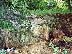
Crilly House Quarry exposes at least 5m of strata belonging to the Carrickaness Sandstone Formation including sandstones, a conglomerate of fossiliferous limestone cobbles and a miospore- rich mudstone. | |
| Description: | |
This very small quarry is located about 120m WSW of the entrance to Crilly House some 3.8km SE of Aughnacloy. The overall inclination of strata is eastwards but there is an unconformity in the middle of the only face separating steeply inclined strata below from virtually horizontal beds above. The lowest rocks in the quarry consist of ~3.3m of pale orange to fawn, purple-stained sandstones, very coarse to coarse-grained and gritty with a calcareous cement. Bedding is well defined 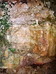 These sandstones are separated by an unconformity from the succeeding conglomerate 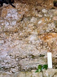 The conglomerate consists mainly of angular blocks of medium grey, medium-grained limestone (packstone) up to 0.15m diameter, together with pieces of clear and white vein quartz set in a matrix of very coarse calcareous sand comprising angular quartz and limestone chips. The base of the bed is erosional into the top of the underlying sandstones. The conglomerate appears to be reverse graded and clast size increases towards the top of the bed. Foraminifera and algae occur in the limestone blocks and include the following forms: Foraminifera: Algae: --------------------------------------------------------------- Archaediscus sp. calcisphaeres Earlandia sp. Draffania biloba Endothyra sp. Donezella sp. Gigasbia gigas Kamaenids Nodosarchaediscus sp. Nannopora anglica Palaeotextularia sp. stacheiinids Paraarchaediscus sp. P. ninae P. stilus Whilst there are no specific guides, the presence of Archaediscus sp. and D. biloba indicates an age no older than Holkerian. The fact that the alga Koninckopora is missing is usually taken to indicate a Brigantian or younger age, but in view of the regional geology and the demonstrable Asbian age of this sandstone elsewhere in the Aughnacloy-Tynan and Benburb areas, this is considered to be unlikely. The conglomerate is overlain by ~0.6m of very coarse-grained, very calcareous, orange-brown (dolomitic?) sandstone with chips of quartz up to 0.01m and of limestone up to 0.03m. The top surface of the conglomerate was evidently an irregular feature and progressively higher levels of the succeeding sandstone rest on the conglomerate in a southwesterly direction. | |
| Interpretation: | |
The occurrence of the intra-formational unconformity, erosion surface and the conglomerate with clasts of limestone the same age as the containing sandstone are good indications of uplift, contemporaneous tectonism and subaerial exposure and erosion of adjacent areas of sea bed. In view of the poorly rounded nature of the limestone clasts it is unlikely that they have been transported from a distant source. Other lithic clasts in the conglomerate appear to consist exclusively of vein quartz suggesting an origin either from a mature weathering profile on a land area or reworking of a pre-existing oligomictic source. Given that there is abundant evidence of regional tectonic activity, accompanied by marine regression and transgression, during Asbian times in many parts of N. Ireland it is hardly surprising to find these sedimentary features in the Carrickaness Sandstone Formation. Quartz-clastic, limestone-boulder conglomerates also occur in the Benburb section (Subarea-6) within the top of the Maydown Limestone Formation. The Crow Hill Conglomerate and Sandstone Member is between 5-6m thick and is located stratigraphically at least 12m below the top of the formation. Whether or not the lithologies exposed in Crilly House Quarry belong to this member or to the Carrickaness Sandstone Formation is not clear, both units being Asbian, but for the present they are assigned to the latter formation. | |
| Conclusions: | |
The exposure in Crilly House Quarry (which is being rapidly infilled with farm refuse) offers a variety of clastic lithologies that in some respects are typical of the Carrickaness Formation and in others are different. | |
| Notes: | |
For information on other sites in Subarea-5 see; Key Site 1178 - Subarea-5; Clogher-Aughnacloy. | |
| Keywords | |
|---|---|
| Rocks: | Conglomerate, Sand, Sandstone |
| Fossil Groups: | Alga, Foraminifera |
| Fossil List: | Archaediscus sp. , Draffania biloba |
| Relations: | Marine sediments, Unconformity |
| Measurements | |||||
|---|---|---|---|---|---|
| Length: | Width: | Height: | 5 m+ | ||
| Depth: | Area: | ||||
| Access | |
|---|---|
| Approach: | 120m WSW of the entrance to Crilly House some 3.8km SE of Aughnacloy. |
| Record type: | ESCR report | ||
| Entered by: | Doughty, P.J. | ||
| Enlander, I., Dempster, M. & Doughty, P., 2026. Crilly House Quarry, Crilly, County Tyrone, site details. [In] Earth Science Conservation Review. https://www.habitas.org.uk/escr/site.php?item=258. Accessed on 2026-11-06. |
| Previous Site | Next Site |