
| Previous Site | Next Site |
Earth Science Conservation Review
| Altmore Burn | Antrim |
| Site number: | 158 | ||
| ESCC: | EC | ||
| Locality Type: | Cliff, Coastal section | Status: | ESCR |
| Grid Reference: | D233398 Centroid | ||
| Google maps: | 55.19035,-6.06399 | ||
| County: | Antrim | Council area: | Causeway Coast & Glens Borough Council |
| Period: | Precambrian | ||
| Stages: | Dalradian | ||
| Lithostrat: | Altmore Formation, Leckpatrick Green Beds, Southern Highlands Group | ||
| Site Description | |
|---|---|
 | |
| Highlights: | |
Altmore Burn flows along the line of the Altmore Fault and contains outcrops of distinctive coarse quartz-feldspar grit and psammite lithologies, part of the Altmore Formation. The site also contains exposures of the Leckpatrick Green Beds, an important marker horizon within the Upper Dalradian Succession in north-east Antrim. | |
| Introduction: | |
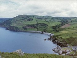
This site encompasses a number of outcrops in the Altmore Burn and on the foreshore of Port-aleen Bay south of Torr Head. It is located approximately 8km north of Cushendun and can be reached by driving towards Torr Head on the scenic coastal route (Torr Road). The site is most easily accessible from the foreshore south of Torr Head. Altmore Burn itself is deeply incised and extensively overgrown making access to this part of the site extremely difficult. On the first edition of the one inch to one mile geological map of the area (Ballycastle, Sheet 8 (Geological Survey of Ireland, 1887), the rocks in Altmore Burn and Port-aleen Bay were simply classified as "gneiss, mica & hornblende schist" and referred to jointly as "crystalline schists". McCallien (1931) produced the first detailed lithostratigraphic map of the Dalradian of north-east Antrim. He adopted the lithostratigraphic nomenclature already in use in Scotland referred the strata in Altmore Burn and Port-aleen Bay to the Pitlochry Schists (Upper Dalradian). McCallien's stratigraphy was predicated on a structural interpretation which viewed the area as the south-westerly continuation into Ireland of recumbent fold structures already identified on the Cowal Peninsula, SW Scotland (Gunn et al., 1897). The second edition of the Ballycastle Sheet, (Geological Survey of Northern Ireland, 1963, Wilson et al., 1966) contained a revised lithostratigraphy based on detailed mapping of the Dalradian and an alternative to Bailey and McCallien's interpretation of the overall structure. A more formal approach to lithostratigraphic nomenclature was adopted for the first edition of the Solid Geology Map of Northern Ireland (Geological Survey of Northern Ireland, 1977) and the rocks around Altmore Burn and Port-aleen Bay were classified as "Quartzose Grit and quartz schist", part of the Altmore Schists as defined by Arthurs (1976). Arthurs revised stratigraphy and structure of north-east Antrim (based on reconnaissance mapping) was incorporated in the second edition of the Solid Geology Map (Geological Survey of Northern Ireland, 1997), see table below. It is probably fair to say that that north-east Antrim is an important area of Dalradian geology which would benefit from further detailed mapping and in-depth study. TABLE TO BE ADDED Dalradian stratigraphy and ESCR sites in North-east Co. Antrim. | |
| Description: | |
In raised cliffs, just north of the mouth of Altmore Burn, there are extensive outcrops of rocks belonging to the Altmore Formation. These are mainly coarse-grained lithologies typically massively bedded (up to 1m thick) units of, pinkish brown weathering, schistose quartzo-feldspathic grit and psammite. The coarsest of these units contain distinctive subrounded bluish-grey flattened and stretched quartz clasts and pink to cream coloured (post-tectonic?) albite porphyroblasts.
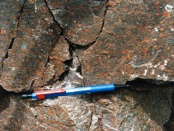 The Altmore Formation dips gently at about 0°-5° towards the north and north-east. Graded bedding and cross laminations, visible in outcrops in the cliff and in the sea stack, indicate that the succession is right way up and younging towards the north. On the foreshore, just south of the Altmore Burn, the grits and gritty psammite beds are locally heavily impregnated with pink feldspathic veins along joints. Crystals of magnetite partly altered to haematite were recorded in a quartz vein on the foreshore close to the mouth of the Burn (Wilson et al., 1966). At the top of the east-facing raised cliff-line, directly south of Altmore Burn, the grits and psammites are overlain by slightly feldspathic (albite) chloritic and hornblendic schists (green beds). These may represent part of the Leckpatrick Green Beds which lie at the base of the Runabay Head Formation which lies structurally beneath and stratigraphically above the Altmore Formation. In the deep gorge cut by the Altmore Burn, outcrops are sporadic and overgrown along the 250m section directly upstream from the mouth of the Burn. On the NE wall, coarse grit and psammite dips at 15° SSW. These rocks exhibit strong mullioned structures plunging at 15° SW (Wilson et al., 1966). Upstream, the schistose grits and quartz schists (Altmore Formation) are terminated by a N-S trending fault which downthrows west bringing massive green metabasite (epidiorite) to outcrop in the bed of the stream. As far upstream as Altmore Bridge [D231 391] the remaining outcrop is structurally complex with epidiorite and quartz-feldspar grit and psammite brought into juxtaposition by a series of minor, partially obscured faults. At the top of this section, very coarse feldspathic grit is exposed in the foundations of Altmore Bridge. Altmore Burn has cut a deep gorge along the line of the Altmore Fault. The crush zone associated with this fault is exposed in the bed of the stream about 175m upstream from the mouth of the Burn in Port-aleen Bay. Although, the main movement on the Altmore Fault is normal (with downthrow on the north-western side), horizontal groove marks on the south-eastern wall of the gorge indicate a significant component of horizontal of movement. | |
| Importance: | |
This site has national and potentially international importance. The stratotype (type section) of the Altmore Formation, though not yet formally designated, is likely to lie within the confines of this site. The detailed interpretation of the structure and stratigraphy of north-east Antrim has not yet been completed. However, it is anticipated that the Altmore Burn and Port-aleen Bay will be a key site for refining stratigraphic correlations within both Antrim and between Antrim, the Sperrin Mountains and Scotland. | |
| Interpretation: | |
During late Proterozoic (Upper Dalradian) times, a series of marine basins developed along the unstable margin of the Laurentian continent. These basins were filled with siliciclastic turbidite facies sediments derived from the nearby continental landmass. The sedimentary basins subsided under the weight of the accumulating sediments. The strata exposed at Altmore Burn and in Port-aleen Bay are a contrasting mixture of coarse siliciclastic and volcanogenic rocks typical of Southern Highland Group successions throughout Northern Britain. The siliciclastic rocks form part of the Altmore Formation which stratigraphically succeeds but structurally lies beneath the Torr Head Formation (Arthurs, 1976). The Altmore Formation occurs in a structural setting and stratigraphic position comparable to the Dart Formation in the Sperrin Mountains and the Ben Bheula Schists in the Cowal Peninsula, Scotland. The presence of green beds is also a common feature of Upper Dalradian stratigraphy throughout Northern Britain. Towards the end of Middle Dalradian times (Tayvallich Subgroup, Argyll Group), the extension and break up of the Laurentian continental margin resulted in crustal thinning and was accompanied by a major upsurge in volcanic activity. This activity, persisted well into Upper Dalradian times and is represented in the stratigraphic record in places by basaltic lavas but more commonly by green beds. The later are predominantly chloritic and amphibolitic rocks believed to be volcanic tuffs of basic to intermediate composition or volcaniclastic sediments derived primarily by erosion of volcanic rocks. The Caledonian Orogeny resulted in deformation and the thermo-dynamic metamorphism of the Dalradian rocks across Northern Britain. In North-east Antrim, as in Scotland and the Sperrin Mountains deformation was complex and polyphase and resulted in folding and the formation of up to four recognisable cleavages (Arthurs, 1976; Goldring, 1961). Structurally, the Altmore Burn now lies close to the core, on the downwards-facing inverted limb, of the Altmore Anticline which is regarded as the south-westerly continuation into Ireland of the Cowal Anticline. (Gunn et al., 1892; Arthurs, 1976). Deformation and regional-scale folding was accompanied by metamorphism. The strata at Altmore Burn and Port-aleen Bay contain mineral assemblages indicative of metamorphism within the quartz-albite-muscovite-chlorite sub-facies of the Greenschist Facies. | |
| Conclusions: | |
Altmore Burn is a site of national and potentially international significance. It provides good reference sections and a potential stratotype for the Altmore Formation and provides access to the Altmore Fault a regionally important structure in North-east Antrim. | |
| Notes: | |
For site specific information and references on other Dalradian sites in North-east Antrim see the following sites: Key Site 155 - Benvan Key Site 156 - Escort Port Key Site 157 - Torr Head Key Site 159 - Leckpatrick Point Key Site 160 - Carnaneigh Key Site 161 - Loughan Bay Key Site 162 - Loughareema Channel Key Site 163 - Knocknacarry Bridge Key Site 164 - Cushendun Bay and Rock Port For site specific information and references on other Dalradian sites in the Sperrin Mountains, Londonderry and Tyrone see the following sites: For Central and Southern Sperrin Mountains: Key Site 130 - Butterlope Glen Key Site 131 - Craig Key Site 132 - Mullaghcarbatagh Key Site 133 - Henry's Bridge, Glensass Burn Key Site 134 - Oughtboy Burn Key Site 135 - Garvagh Burn Key Site 136 - Barnes Gap Key Site 137 - Barnes Burn Key Site 138 - Golan Burn Key Site 139 - Glendarragh Burn, Glenlark Key Site 140 - Mountfield Old Quarry Key Site 141 - McNally's Burn, Broughderg For North Sperrin Mountains and Londonderry: Key Site 142 - Letterbrat Quarry Key Site 143 - Banagher Glen Quarry Key Site 144 - Strabane Quarry Key Site 145 - Glenmornan River, Artigarvan Key Site 146 - Balix Hill Key Site 147 - Drain Quarry Key Site 148 - Kildoag Quarry Key Site 149 - Loughermore Mountain Key Site 150 - Burntollet and Tamnymore Wood Key Site 151 - Dog Leap, Limavady Key Site 152 - Kittybane Quarry Key Site 153 - Prehen Quarry Key Site 154 - Creevagh Hill Old Quarry For general information on the Dalradian rocks of Northern Ireland see the following site: Key Site 124 - The Dalradian Rocks of Northern Ireland For general and site specific information on the Pre-Dalradian rocks of Northern Ireland see the following site: Key Site 123 - The Pre-Dalradian Rocks of Northern Ireland For general information and an extensive reference list on the Precambrian of Northern Ireland see the following site: Key Site 122 - An Introduction to the Precambrian of Northern Ireland | |
| Keywords | |
|---|---|
| Rocks: | Green beds, Grit, Psammite |
| Structures: | fault |
| Access | |
|---|---|
| Approach: | For a distance of about 600m downstream of Altmore Bridge there is no safe access to the bed of the stream via these banks. It is therefore recommended that the Altmore Burn is approached either from the coast or via the small west bank tributary which enters Altmore Burn at [D233 398], about 100m from the shoreline. |
| Management: | |
Most of the site lies within an area currently under the stewardship of the National Trust a fact which may have implications for access to the site or parts of the site and for sampling policy. Notwithstanding any views that the National Trust may have regarding hammering and sampling at this site, I see no geological reasons for imposing sampling restrictions at this site. From the point of view of safety and access to the site, it should be noted that the sides of the valley and gorge of the Altmore Burn are steep, overgrown and generally wet. For a distance of about 600m downstream of Altmore Bridge there is no safe access to the bed of the stream via these banks. It is therefore recommended that the Altmore Burn is approached either from the coast or via the small west bank tributary which enters Altmore Burn at [D233 398], about 100m from the shoreline. | |
| Threats: | At present there do not appear to be any identifiable threats to the integrity of this site. |
| References (6) | |||
|---|---|---|---|
| Arthurs, J.W., 1976a. The geology and metalliferous mineral potential of the Sperrin Mountains area Geological Survey of Northern Ireland Special Report. | |||
| Bailey, E.B. & McCallien, W.J., 1934. The metamorphic rocks of North-east Antrim Transactions of the Royal Society of Edinburgh: Earth Sciences, vol. 58, pp.163-177. | |||
| Golding, D.C., 1961. The relationship of the micro-fabric to the small-scale structures of the Dalradian of north-eastern Antrim Proceedings of the Royal Irish Academy, vol. 61 pt. B, pp.345-367. | |||
| Gunn, W., Clough, C.T. & Hill, J.B., 1897. The Geology of Cowal Memoir of the Geological Survey of Scotland. | |||
| McCallien, W.J., 1931. A contribution to the correlation of the Dalradian rocks of Scotland Geological Magazine, vol. 68, pp.153-175. | |||
| Wilson, H.E. & Robbie, J.A., 1966. Geology of the country around Ballycastle. Memoirs of the Geological Survey Northern Ireland. | |||
| Map(s): | GSI (1887). 1:63,360 Geological Sheet 8 (Ballycastle), Dublin, OS for GSI GSNI (1963). 1:63,360 Ballycastle, Northern Ireland Sheet 8, Drift, Southampton, OS for GSNI GSNI (1977). 1:250,000 Northern Ireland, Solid Geology (1st edition), Southampton, OS for IGS GSNI (1997). 1:250,000 Northern Ireland, Solid Geology (2nd edition), BGS, Keyworth, Nottingham | ||
| Record type: | ESCR report | ||
| Entered by: | E M Porter | ||
| Enlander, I., Dempster, M. & Doughty, P., 2026. Altmore Burn, County Antrim, site details. [In] Earth Science Conservation Review. https://www.habitas.org.uk/escr/site.php?item=158. Accessed on 2026-11-03. |
| Previous Site | Next Site |