
| Previous Site | Next Site |
Earth Science Conservation Review
| Ederney Quary - Carboniferous | Fermanagh |
| Site number: | 227 | File Number: | H26 |
| ESCC: | ED | ||
| Locality Type: | Quarry (disused) | Status: | ASSI |
| Grid Reference: | H224641 Centroid | ||
| Google maps: | 54.52524,-7.65403 | ||
| County: | Fermanagh | Council area: | Fermanagh & Omagh District Council |
| Period: | Carboniferous | ||
| Stages: | Arundian, Visean | ||
| Lithostrat: | Ballyshannon Limestone Formation, Bundoran Shale Formation, Crockanaver Limestone Member, Dromore Sandstone Member, Ederny Limestone Member, Mullaghmore Sandstone, Skea Sandstone Member, Tyrone Group | ||
| Site Description | |
|---|---|
 | |
| Highlights: | |
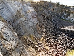
Ederny Quarry exposes a thick section of strata at the top of the Ballyshannon Limestone Formation including the stratotype section for the Ederny Limestone Member. This is overlain by the Skea Sandstone Member of the Bundoran Shale Formation and the succeeding basal beds of that formation. EDERNY LIMESTONE MEMBER The thickness of the Ederny Member varies from 2.5m to 5.5m. The micritisation was a secondary process that affected normal packstones of the Ballyshannon Limestone Formation during an episode of regional shallowing of the sea. Passage of carbonate- rich brine through the bedrock occurred at this time and caused the alteration of the whole rock fabric, including any fossil material, to very fine-grained micrite. This process destroys original fabrics and causes volumetric changes which, in conjunction with karstification disrupts the physical appearance of the rock, leading to the formation of nodular limestones and pseudobreccias. Thin irregular shale wisps envelop the limestone nodules and bedding continuity is disrupted. No reddening of the rock is evident. Cathodoluminescence studies of carbonate cements in these limestones suggest that micritisation was a submarine effect. These data, in conjunction with the total absence of primary reddening (a feature of subaerial exposure, compare the examples in Armagh (Subarea-6; Site 275) and Cookstown Quarry (Subarea-7; Site 280)) are believed to indicate that the top of the Ballyshannon Limestone was not emergent and that alteration of the limestones occurred in very shallow water. Downward percolation of micritising fluids, and hence the thickness of the Ederny Member was, at most localities where it is fully exposed, controlled by the occurrence of shales intervening in the limestone sequence. In the stratotype section, for example, the shale bed that marks the base of the member is 0.15m thick and grainstones of the Crockanaver Member, that occur below the shale, show no trace of micritisation. The top of the Ederny Member is at most localities a flat surface that does not show any marked irregularities or indications of erosion. In the stratotype quarry this surface is overlain by soft multicoloured laminated clays. | |
| Description: | |
Ederny Quarry is a large abandoned excavation into the northern side of an extensive outcrop of Ballyshannon Limestone that forms the western end of Carnridge. The height of the quarry faces increases rapidly towards the south end of the quarry which is marked by the exposed plane of the Aghaleague Fault (1:50,000 Sheet 33), which is inclined at about 50 deg. to the northwest. The Ederny Limestone is exposed at floor level on both sides of the north end of the quarry and forms the rim of the higher faces towards the south end. The stratotype locality is at the NW edge of the quarry where the Ederny Member is 4.8m thick. It consists of typical pale to medium grey rubbly and nodular, poorly bedded micritised limestones. The 0.15m thick silty shale with thin limestones is best exposed at the north end of the quarry. Lying below this shale are some 8m of grainstones of the Crockanaver Member and the lowest beds in the quarry are the dark grey interbedded packstones and thin shales, with the horizon of nodular chert, that are more accessible in Crockanaver Quarry. The top of the Ederny Member is overlain by 0.18m of thinly coloured banded pale green, yellow and brown micaceous, very soft clay. This is only preserved in the stratotype section in the NW corner. Directly succeeding this clay horizon is a bed of medium grey, quartzose limestone 1.38m thick containing crinoid ossicle debris and fragments of brachiopods. This is exposed on both sides of the quarry and in the stratotype section and is the local, distal, representative of the Skea Sandstone Member, the basal unit in the Kesh-Omagh area, of the Bundoran Shale Formation. Lying above this bed, and only exposed at the top of the quarry in the SE corner are about 1.3m of grey shaley mudstones with thin calcareous bioturbated sandstones and very thin sandy limestones containing bivalves, brachiopods, bryozoa and echinoid spines. These are the basal beds of the Bundoran Shale Formation. In the extreme NE corner of the quarry, behind the office buildings are about 3m of orange-weathering, bedded, decalcified, fine to medium-grained sandstones containing abundant specimens of bivalves, occasional brachiopods, crinoid ossicles, gastropods and ?trilobites. These sandstones belong to the Dromore Sandstone Member, the basal unit of the Mullaghmore Sandstone Formation, which is well exposed in quarry sections in the Kesh area (1:50,000 Sheet 32) west of this quarry. | |
| Interpretation: | |
The succession of environments that are represented by the sedimentary rocks exposed in Ederny Quarry is extremely varied. Most significant however is the recognition of consistent upward shallowing of water depths on the shelf sea in which the Ballyshannon Limestone was deposited, as evidenced by the occurrence of grainstones (including of few ooliths) of the Crockanaver Limestone Member. Micritisation of the top few metres of the Ballyshannon Limestone, and the formation of the distinctive Ederny Limestone Member, occurred in very shallow water, in a sediment-starved location. In view of the widespread outcrop of the Ederny Member, covering over 300km2 of the Kesh- Omagh area, it is hardly surprising that sources of land-derived detritus were remote from most areas of this flat submerged surface. The multicoloured clays covering the top of the Ederny Limestone in the stratotype represent a water lain deposit comprising the finest fraction of the denudation cycle. It is also possible that some of the clay particles comprise wind-blown sediment carried from distant land areas. Asymmetrical uplift of land areas to the north of the Kesh-Omagh area resulted in the erosion of coarse debris and inundation of the shallow sea by coarse clastic sediment, the Skea Sandstone Member. In Ederny Quarry this member is represented by a quartz- bearing crinoidal limestone, representing a truly marine shelf deposit beyond the distal extremity of the sand fan that represents the Skea Member. Basal strata of the Bundoran Shale Formation consist of very shallow water, fine-grained clastics with marine fossils and abundant bioturbation features in the south and peritidal facies sediments in the north. Increasing water depths accompanying the regional transgression at the base of the Bundoran Shale resulted in the disappearance of coarse clastic sediment as the coastline moved northwards and sediment now consists exclusively of mud and silt grade particles, with an abundant marine benthos. | |
| Conclusions: | |
Ederny Quarry is the stratotype of the Ederny Limestone Member. It also provides a marvellous section through the varied sedimentary rocks at the top and base of the Ballyshannon Limestone and Bundoran Shale formations respectively. | |
| Notes: | |
For information on other sites in Subarea-3 see; Key Site 1176 - Subarea-3; Kesh-Omagh. This site is also important for Structural Geology. See Key Site 657 - Ederny Quarry. | |
| Keywords | |
|---|---|
| Rocks: | Limestone, Sand, Sandstone, Shale |
| Fossil Groups: | Bivalve, Brachiopod, Crinoid, Echinoderm, Gastropod, Polyzoan, Trilobite |
| Structures: | fault |
| Relations: | Marine sediments |
| Access | |
|---|---|
| Approach: | 900m SSE of Ederny. |
| Map(s): | GSNI 1:50,000 Sheets 33 and 32. | ||
| Record type: | ESCR report | ||
| Entered by: | Doughty, P.J. | ||
| Last updated: | 6 Jun 2005 | ||
| Enlander, I., Dempster, M. & Doughty, P., 2026. Ederney Quary - Carboniferous, County Fermanagh, site details. [In] Earth Science Conservation Review. https://www.habitas.org.uk/escr/site.php?item=227. Accessed on 2026-11-06. |
| Previous Site | Next Site |